 Filter: Categories of Wisconsin Historical Images
Filter: State of Minnesota
Filter: Subject of superior, lake
Filter: Categories of Wisconsin Historical Images
Filter: State of Minnesota
Filter: Subject of superior, lake
| Date: | |
|---|---|
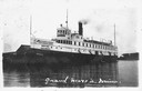
| Description: | The screw passenger and freight vessel, America, docked. Sign on boat reads: "United States and Dominion Transportation Company, Booth Line, U.S. Ma... |

| Date: | 1989 |
|---|---|
| Description: | This color coded map shows the various rivers, lakes, bays, and islands that make up the harbor. It includes an index of industries (maritime and non-marit... |

| Date: | 1871 |
|---|---|
| Description: | This map shows the entire state, county boundaries, railroads, cities and towns, Lake Superior, and the extent of surveyed townships with Public Land Surve... |

| Date: | 1914 |
|---|---|
| Description: | A view from Beaver Bay in Lake Superior of houses on the shoreline. |

| Date: | 1914 |
|---|---|
| Description: | Elevated view from the lake of the Lake Superior Palisades. |

| Date: | 1914 |
|---|---|
| Description: | A view across the water towards Five Mile Rock, a large rock formation off the north shore of Lake Superior. |
| Date: | 1914 |
|---|---|
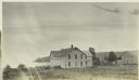
| Description: | View across field towards the Chicago Bay Boarding House. The lake is in the background on the left. Chicago Bay, Minnesota, is now called Hovland. |
| Date: | |
|---|---|
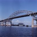
| Description: | View across water towards the Duluth-Superior bridge. |

| Date: | |
|---|---|
| Description: | Oversized "Colortone" postcard view across water towards the Split Rock Lighthouse from the waterline, looking up the bluffs, with other buildings along th... |
If you didn't find the material you searched for, our Library Reference Staff can help.
Call our reference desk at 608-264-6535 or email us at: