 Filter: Categories of Wisconsin Historical Images
Filter: State of Minnesota
Filter: Subject of bays
Filter: Categories of Wisconsin Historical Images
Filter: State of Minnesota
Filter: Subject of bays

| Date: | 1989 |
|---|---|
| Description: | This color coded map shows the various rivers, lakes, bays, and islands that make up the harbor. It includes an index of industries (maritime and non-marit... |

| Date: | 1914 |
|---|---|
| Description: | A view from Beaver Bay in Lake Superior of houses on the shoreline. |
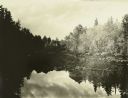
| Date: | 1910 |
|---|---|
| Description: | A view at the end of a bay of mirror images of trees on a lake. |

| Date: | |
|---|---|
| Description: | View from shoreline of the Duluth-Superior high bridge. |
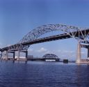
| Date: | |
|---|---|
| Description: | View across water towards the Duluth-Superior bridge. |
If you didn't find the material you searched for, our Library Reference Staff can help.
Call our reference desk at 608-264-6535 or email us at: