 Filter: Categories of Wisconsin Historical Images
Filter: State of Michigan
Filter: Year of 1800-1899
Filter: Subject of islands
Filter: Categories of Wisconsin Historical Images
Filter: State of Michigan
Filter: Year of 1800-1899
Filter: Subject of islands
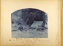
| Date: | 1889 |
|---|---|
| Description: | Beach fishing camp showing several people around a fire drying fish with a tent in the background. Captioned: Ottawa Fishing Camp -- On the Island at Fran... |

| Date: | 1899 |
|---|---|
| Description: | A young Aldo Leopold posing proudly with his bamboo fishing pole, stringer of perch and a dog. The family was on vacation in the Cheneaux Islands, near Mac... |

| Date: | 1836 |
|---|---|
| Description: | This map shows Havre Bay, a part of Maumee Bay, parts of Indian Island, Gard’s Island (Michigan), the Ottawa River, Vance River, creeks, and Ottawa Point (... |

| Date: | 1893 |
|---|---|
| Description: | This map shows the depths of the East Neebish Rapids and the different types of minerals that make up the floor bed. Islands and Canada West is labeled. No... |
If you didn't find the material you searched for, our Library Reference Staff can help.
Call our reference desk at 608-264-6535 or email us at: