 Filter: Categories of Wisconsin Historical Images
Filter: State of Michigan
Filter: Subject of rivers
Filter: Categories of Wisconsin Historical Images
Filter: State of Michigan
Filter: Subject of rivers

| Date: | 1821 |
|---|---|
| Description: | Engraving depicting the Schoolcraft expedition crossing the Ontonagon River to investigate a copper boulder. |
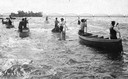
| Date: | 07 16 1898 |
|---|---|
| Description: | A group of Ojibwa men fishing from boats. |
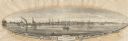
| Date: | 1855 |
|---|---|
| Description: | View of Detroit with several boats and ships in (probably) the Detroit River. |

| Date: | 1930 |
|---|---|
| Description: | The front and back of a postcard featuring a drawing of the Detroit skyline as seen from Windsor, Ontario that was sent by Alice and Floyd Quinney during t... |
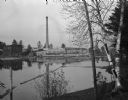
| Date: | |
|---|---|
| Description: | View from shoreline toward the Grand Rapids lumber mill with a smokestack on the opposite shoreline. |
| Date: | 07 30 1865 |
|---|---|
| Description: | An exterior view across water of Robert Stephenson & Company Mill, which was a steam mill. |

| Date: | 1933 |
|---|---|
| Description: | View of the Woodbine Country Club on Presque Isle River. An automobile is parked on the side of the road near the County Club sign which says “Woodbine Cou... |
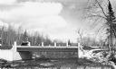
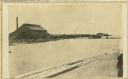
| Date: | 1936 |
|---|---|
| Description: | View from shoreline of a bridge over the Ontonagon River. There is snow on the ground with bare the trees in the background. |
| Date: | |
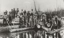
|---|---|
| Description: | View over water of Michigan lumbering scene, where men roll logs into the river. The group of men are posed holding peaveys and cant hooks or peaveys, tool... |

| Date: | 1900 |
|---|---|
| Description: | View from rocky shoreline across river towards a man standing on rocks and holding a stick in front of a rock face on the opposite shoreline. There are lar... |

| Date: | 1836 |
|---|---|
| Description: | This map shows Havre Bay, a part of Maumee Bay, parts of Indian Island, Gard’s Island (Michigan), the Ottawa River, Vance River, creeks, and Ottawa Point (... |

| Date: | 1858 |
|---|---|
| Description: | This map shows the depth of the West Channel and the different types of minerals that make up the floor bed. The steamboat range station is labeled. A note... |

| Date: | 1893 |
|---|---|
| Description: | This map shows the depths of the East Neebish Rapids and the different types of minerals that make up the floor bed. Islands and Canada West is labeled. No... |

| Date: | 1851 |
|---|---|
| Description: | This map shows townships, villages, Indian villages, railroads, roads, mills, prairies, swamps, and canals. An inset map shows a plat of the copper distric... |

| Date: | 1864 |
|---|---|
| Description: | This map shows land owners, buildings, cities and villages, lakes, rivers, and roads. The margins include inset maps: Berlin; Mill Point; Holland; Ferrisvi... |

| Date: | 1909 |
|---|---|
| Description: | The Gang loading their travel supplies at a campsite. From left to right are: Doc Copeland, Howard T. Greene, Bill Marr, Fred Carr, and Howard Greene. |

| Date: | 1909 |
|---|---|
| Description: | View across water from shoreline towards a railroad bridge at a camp near Marenisco, Michigan. There is a log building on the opposite shoreline. |
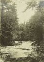
| Date: | 1909 |
|---|---|
| Description: | Cascades on the Presque Isle River near The Gang's camp. |
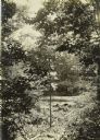
| Date: | 1909 |
|---|---|
| Description: | A view through foliage of the canoes at the Presque Isle River, where The Gang completed their first portage of the trip. |

| Date: | 1909 |
|---|---|
| Description: | Exterior view of a diamond drill outfit on Presque Isle River. |
If you didn't find the material you searched for, our Library Reference Staff can help.
Call our reference desk at 608-264-6535 or email us at: