 Filter: Categories of Wisconsin Historical Images
Filter: State of Massachusetts
Filter: Subject of waterfalls
Filter: Categories of Wisconsin Historical Images
Filter: State of Massachusetts
Filter: Subject of waterfalls
| Date: | |
|---|---|
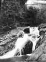
| Description: | View from below of the mill at New Ashford with the waterfall below. Caption reads: "Mill at New Ashford from Williamstown, Mass." |
| Date: | |
|---|---|
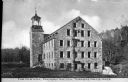
| Description: | View toward the old mill, an old stone building with a tower and a waterfall behind it. Caption reads: "The Old Mill, Factory Hollow, Turners Falls, Mass." |

| Date: | |
|---|---|
| Description: | View of a landscape with a rocky stream in foreground and town set in countryside in the distance. Shelburn Falls can be seen among industrial and resident... |

| Date: | 1775 |
|---|---|
| Description: | Map of Boston and surrounding regions, from Massachusetts Bay to the Connecticut River, and including part of southern New Hampshire. It shows the colonies... |

| Date: | 1780 |
|---|---|
| Description: | Map of eastern Massachusetts, Rhode Island, eastern Connecticut, and small portions of New Hampshire and Vermont. It shows the boundaries, counties, citie... |
If you didn't find the material you searched for, our Library Reference Staff can help.
Call our reference desk at 608-264-6535 or email us at: