 Filter: Categories of Wisconsin Historical Images
Filter: State of Massachusetts
Filter: Subject of ocean
Filter: Categories of Wisconsin Historical Images
Filter: State of Massachusetts
Filter: Subject of ocean
| Date: | |
|---|---|
| Description: | Eastern Point Lighthouse at "Mother Ann" and residence on rocky point, Gloucester, Massachusetts. Mother Ann is a rocky cliff at the far south end of Easte... |
| Date: | |
|---|---|
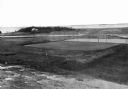
| Description: | Elevated view of golf links featuring Squaw Island in the distance. |
| Date: | |
|---|---|
| Description: | Elevated view of Castle Rock, located on the coast, with numerous people looking out over the water. Caption reads: "Castle Rock, Marblehead, Mass." |

| Date: | |
|---|---|
| Description: | Elevated view of village homes on the shores of the bay with docked fishing boats in the foreground. Caption reads, "Marblehead, Mass from Rockmere Point." |

| Date: | |
|---|---|
| Description: | Hand-drawn map of the area at the time of Pilgrim landing, drawn by Charles Blaskowikz. Includes commemorative historical notes. |
| Date: | |
|---|---|
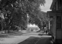
| Description: | View of Plymouth Street looking towards the waterfront with large trees along the sidewalks. |
| Date: | |
|---|---|
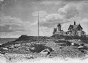
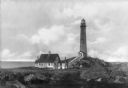
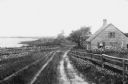
| Description: | View across rocky ground and grass toward the Northern Lighthouse and the nearby cottage. A covered walkway leads from the house up to the entrance of the ... |

| Date: | |
|---|---|
| Description: | Adults and children posing on and in front of Lover's Rock, which is partially submerged in water. Several sailboats are on the horizon. Caption reads: "Lo... |
| Date: | |
|---|---|
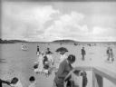
| Description: | A view of the shore and ocean at Good Harbor Beach. People in the foreground are using a set of wooden steps to exit the beach area while other people are ... |
| Date: | |
|---|---|
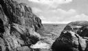
| Description: | A person rows a rowboat near the rocky cliffs at Gap Head. |

| Date: | |
|---|---|
| Description: | View along shoreline toward a lighthouse and homes standing on Rocky Point. There are several boats anchored at the shore and in the water. |

| Date: | |
|---|---|
| Description: | A rocky coast is populated with homes, hotels, and a lighthouse. |
| Date: | |
|---|---|
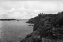
| Description: | View of Kettle Island as seen from Coolidge Point. A residence stands among trees on Coolidge Point. |
| Date: | |
|---|---|
| Description: | View of a cottage separated from Oyster Pond by fences and an unpaved road. |

| Date: | |
|---|---|
| Description: | View of expansive gardens rolling down to a harbor. |

| Date: | 1853 |
|---|---|
| Description: | A map of Wellfleet Harbor on Cape Cod Bay. |
If you didn't find the material you searched for, our Library Reference Staff can help.
Call our reference desk at 608-264-6535 or email us at:
