 Filter: Categories of Wisconsin Historical Images
Filter: State of Massachusetts
Filter: Subject of mountains
Filter: Categories of Wisconsin Historical Images
Filter: State of Massachusetts
Filter: Subject of mountains
| Date: | |
|---|---|
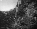
| Description: | Three men and five women posing in a rocky, wooded ravine. Caption reads: "Purgatory- Sutton, Mass." |
| Date: | |
|---|---|
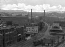
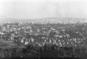
| Description: | Elevated view of industrial section of town showing railroad tracks, brick warehouses, smokestacks and the mountains on the outskirts of town in the backgr... |
| Date: | |
|---|---|
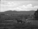
| Description: | Bear Town Mountain from Cherry Hill. A man and a horse-drawn wagon are posing near homes that are scattered through the valley setting. |
| Date: | |
|---|---|
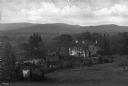
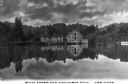
| Description: | View of a large residence surrounded by trees. The mansion sits on a large piece of property with a pond, and a mountainous countryside is in the distance. |
| Date: | |
|---|---|
| Description: | Columbia Mill, established in 1827, is shown surrounded by a landscape featuring a lake and wooded mountain. The mill is the site where the first successfu... |
| Date: | |
|---|---|
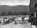
| Description: | A man wearing a cowboy hat leads a horse from a stable towards other horses hitched to a fence. Mountains stand in the background. |

| Date: | |
|---|---|
| Description: | Men stand near an automobile parked along Mohawk Trail, a historic road surrounded by trees, to view a scenic overlook. |
| Date: | |
|---|---|
| Description: | Elevated view of Holyoke buildings with Mount Tom in the distance. |
| Date: | |
|---|---|
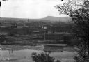
| Description: | Elevated view of town buildings as seen from Bancroft Tower. A body of water and what appears to be an industrial plant are in the foreground. |
| Date: | |
|---|---|
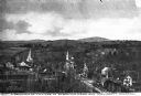
| Description: | Church steeples and village dwellings are visible amidst trees, backed by the Wachusett Mountain. Published by E.P. Bartlett. |

| Date: | 1775 |
|---|---|
| Description: | Map of Boston and surrounding regions, from Massachusetts Bay to the Connecticut River, and including part of southern New Hampshire. It shows the colonies... |

| Date: | 1780 |
|---|---|
| Description: | Map of eastern Massachusetts, Rhode Island, eastern Connecticut, and small portions of New Hampshire and Vermont. It shows the boundaries, counties, citie... |

| Date: | 1795 |
|---|---|
| Description: | Map of Massachusetts showing counties, cities, roads, islands (including Nantucket and Martha's Vineyard), mountains, hills, lakes, and rivers. Two small e... |
| Date: | 1950 |
|---|---|
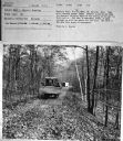
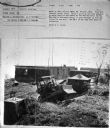
| Description: | Subject: "TD-9 — Material Handling." Where Taken: "NE." Information with photograph reads: "Owned by Radio Station WHYN, Mt. Holyoke, Mass. Used with Isaac... |
| Date: | 1950 |
|---|---|
| Description: | Subject: "TD-9 — Material Handling." Where Taken: "NE." Information with photograph reads: "Owned by Radio Station WHYN, Mt. Holyoke, Mass. Used with Isaac... |
If you didn't find the material you searched for, our Library Reference Staff can help.
Call our reference desk at 608-264-6535 or email us at: