 Filter: Categories of Wisconsin Historical Images
Filter: State of Massachusetts
Filter: Subject of landforms
Filter: Categories of Wisconsin Historical Images
Filter: State of Massachusetts
Filter: Subject of landforms
| Date: | |
|---|---|
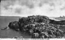
| Description: | Elevated view of Castle Rock, located on the coast, with numerous people looking out over the water. Caption reads: "Castle Rock, Marblehead, Mass." |

| Date: | |
|---|---|
| Description: | Hand-drawn map of the area at the time of Pilgrim landing, drawn by Charles Blaskowikz. Includes commemorative historical notes. |

| Date: | 1853 |
|---|---|
| Description: | A map of Wellfleet Harbor on Cape Cod Bay. |
If you didn't find the material you searched for, our Library Reference Staff can help.
Call our reference desk at 608-264-6535 or email us at:
