 Filter: Categories of Wisconsin Historical Images
Filter: State of Massachusetts
Filter: Subject of lakes
Filter: Categories of Wisconsin Historical Images
Filter: State of Massachusetts
Filter: Subject of lakes
| Date: | |
|---|---|
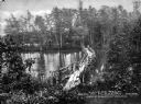
| Description: | A narrow rustic bridge crossing a pond in a wooded area known as Lovers' Walk. Caption reads: "Lovers' Walk, Near Mt. Pleasant House, Jefferson, Mass." |
| Date: | |
|---|---|
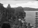
| Description: | Elevated view of Hunnewell arboretum featuring a a hill with rows of topiary, Lake Wauban and surrounding woods. |
| Date: | |
|---|---|
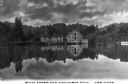
| Description: | Columbia Mill, established in 1827, is shown surrounded by a landscape featuring a lake and wooded mountain. The mill is the site where the first successfu... |
| Date: | |
|---|---|
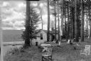
| Description: | A man and woman sit in front of a cabin in Gibson's Grove on Lake Buell. Multiple benches and chairs stand on the lawn looking over the water. |

| Date: | |
|---|---|
| Description: | Elevated view of people sunbathing and relaxing on the beach at Wickett Island, while others wade in the lake. |

| Date: | |
|---|---|
| Description: | Rustic benches stand in a lookout area along a wooded path at Wellesley College. |
| Date: | |
|---|---|
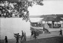
| Description: | Elevated view of people walking along the shore of Lake Chaubunagungamaug (also known as Webster Lake) in Beacon Park while an excursion boat waits at the ... |

| Date: | 1775 |
|---|---|
| Description: | Map of Boston and surrounding regions, from Massachusetts Bay to the Connecticut River, and including part of southern New Hampshire. It shows the colonies... |

| Date: | 1780 |
|---|---|
| Description: | Map of eastern Massachusetts, Rhode Island, eastern Connecticut, and small portions of New Hampshire and Vermont. It shows the boundaries, counties, citie... |

| Date: | 1795 |
|---|---|
| Description: | Map of Massachusetts showing counties, cities, roads, islands (including Nantucket and Martha's Vineyard), mountains, hills, lakes, and rivers. Two small e... |
If you didn't find the material you searched for, our Library Reference Staff can help.
Call our reference desk at 608-264-6535 or email us at: