 Filter: Categories of Wisconsin Historical Images
Filter: State of Massachusetts
Filter: Subject of islands
Filter: Categories of Wisconsin Historical Images
Filter: State of Massachusetts
Filter: Subject of islands
| Date: | |
|---|---|
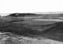
| Description: | Elevated view of golf links featuring Squaw Island in the distance. |

| Date: | |
|---|---|
| Description: | Hand-drawn map of the area at the time of Pilgrim landing, drawn by Charles Blaskowikz. Includes commemorative historical notes. |

| Date: | |
|---|---|
| Description: | Residences are shown on Main Street, exhibiting the colonial revival style. |
| Date: | |
|---|---|
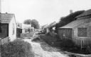
| Description: | A view along the backs of cottages on a village lane in Siaconset, Nantucket Island. Shrubs line the unpaved road, and fences demarcate each cottage's yard... |
| Date: | |
|---|---|
| Description: | View of Kettle Island as seen from Coolidge Point. A residence stands among trees on Coolidge Point. |

| Date: | |
|---|---|
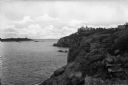
| Description: | Elevated view of Wickets Island, a small island in a bay with dense foliage. A large tower is on the island and boats are in the bay. |
| Date: | |
|---|---|
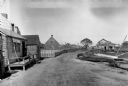
| Description: | General view of town streets, with a harbor and early American store exteriors. |

| Date: | 1795 |
|---|---|
| Description: | Map of Massachusetts showing counties, cities, roads, islands (including Nantucket and Martha's Vineyard), mountains, hills, lakes, and rivers. Two small e... |

| Date: | 1853 |
|---|---|
| Description: | A map of Wellfleet Harbor on Cape Cod Bay. |
If you didn't find the material you searched for, our Library Reference Staff can help.
Call our reference desk at 608-264-6535 or email us at: