 Filter: Categories of Wisconsin Historical Images
Filter: State of Massachusetts
Filter: Subject of engraving
Filter: Categories of Wisconsin Historical Images
Filter: State of Massachusetts
Filter: Subject of engraving
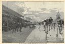
| Date: | 09 1886 |
|---|---|
| Description: | Engraved image of a drawing by Henry Sandham showing six bicycle racers on a track with a large crowd of spectators in the stands and along the side of the... |
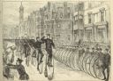
| Date: | 05 30 1881 |
|---|---|
| Description: | Engraving of a sketch by Joseph Pennell showing a parade of League of American Wheelmen bicyclists along Commonwealth Avenue between Dartmouth Street and W... |

| Date: | 1775 |
|---|---|
| Description: | Map of Boston and surrounding regions, from Massachusetts Bay to the Connecticut River, and including part of southern New Hampshire. It shows the colonies... |

| Date: | 1780 |
|---|---|
| Description: | Map of eastern Massachusetts, Rhode Island, eastern Connecticut, and small portions of New Hampshire and Vermont. It shows the boundaries, counties, citie... |

| Date: | 1795 |
|---|---|
| Description: | Map of Massachusetts showing counties, cities, roads, islands (including Nantucket and Martha's Vineyard), mountains, hills, lakes, and rivers. Two small e... |
If you didn't find the material you searched for, our Library Reference Staff can help.
Call our reference desk at 608-264-6535 or email us at: