 Filter: Categories of Wisconsin Historical Images
Filter: State of Louisiana
Filter: Subject of transportation
Filter: Categories of Wisconsin Historical Images
Filter: State of Louisiana
Filter: Subject of transportation
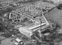
| Date: | 1920 |
|---|---|
| Description: | Aerial view of the Baldwin Lumber Company, which sits next to a river. The main building consists of two long, rectangular structures that sit perpendicula... |

| Date: | |
|---|---|
| Description: | View looking down hill toward the sawmill and logs floating in the pond. Company outbuildings are on the left, with a smokestack and silo. A water tower is... |
| Date: | |
|---|---|
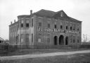
| Description: | A view from across the dirt path of Louisiana Baptist Orphanage, constructed in 1903. A fence surrounds the building which has tall windows. |

| Date: | |
|---|---|
| Description: | View down Nicholas and Royal Streets. Men stand on the sidewalk near a cafe and lunch room. |

| Date: | |
|---|---|
| Description: | View down sidewalk on left side of Royal Street featuring two men near a market on the right. An iron fence is on the left side of the street. |

| Date: | |
|---|---|
| Description: | View from across the water of Bogue Falaya Landing and Boat House. Published by C.C. Champagne & Co. |

| Date: | |
|---|---|
| Description: | View down a street lined with parked cars and small businesses. |

| Date: | 09 22 1938 |
|---|---|
| Description: | A man loads boxes and packages into the back of an International D-2 truck owned by the Chalmette Laundry division of the Crescent City Laundries, Incorpor... |

| Date: | |
|---|---|
| Description: | View of railroad cars being ferried across the river. |

| Date: | 1995 |
|---|---|
| Description: | View towards an International model 3400 Commercial Bus parked in front of the Hotel de la Monnaie. The bus is white with red and blue stripes, with the "I... |

| Date: | 1759 |
|---|---|
| Description: | Map of New Orleans at the start of the French & Indian War, including two inset maps entitled "The Course of the Mississipi River from Bayagoulas to the Se... |

| Date: | 1769 |
|---|---|
| Description: | Map of New Orleans at the start of the French & Indian War, including two inset maps of the Mississippi River Delta and Fort la Balise. It shows streets, r... |

| Date: | 1761 |
|---|---|
| Description: | Map of New Orleans with north oriented towards the upper right corner. It shows the land around the city, the Mississippi River, anchorages, roads leading ... |
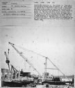
| Date: | 1950 |
|---|---|
| Description: | Subject: "U-9 — Material Handling." Where Taken: "SW." Information with photograph reads: "Owned by The California Co., New Orleans, La. Used with a derric... |

| Date: | 1950 |
|---|---|
| Description: | Subject: "U-9 — Oil Field Pumping." Where Taken: "SE." Information with photograph reads: "Owned by Koch & Ellis, Balter Bldg., New Orleans, La. Used with ... |

| Date: | 1950 |
|---|---|
| Description: | Subject: "Multiple Tractor Scenes — Parks, Cemeteries, Etc." Where Taken: "SW." Information with photograph reads: "Used by the Fairgrounds Race Track (New... |
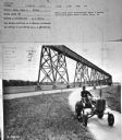
| Date: | 1950 |
|---|---|
| Description: | Subject: "Inter. Super A — Mowing." Where Taken: "SE." Information with photograph reads: "Photo shows first International Super A tractor and AI-23 highwa... |
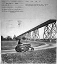
| Date: | 1950 |
|---|---|
| Description: | Subject: "Inter. Super A — Mowing." Where Taken: "SE." Information with photograph reads: "Photo shows first International Super A tractor and AI-23 highwa... |

| Date: | 1950 |
|---|---|
| Description: | Subject: "U-4 — Oil Field Preparation." Where Taken: "SW." Information with photograph reads: "Owned by the Danciger Drilling & Refining Co., Baton Rouge, ... |
If you didn't find the material you searched for, our Library Reference Staff can help.
Call our reference desk at 608-264-6535 or email us at: