 Filter: Categories of Wisconsin Historical Images
Filter: State of Louisiana
Filter: Subject of roads
Filter: Categories of Wisconsin Historical Images
Filter: State of Louisiana
Filter: Subject of roads
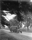
| Date: | 07 14 1926 |
|---|---|
| Description: | International truck owned by Forestdale Farm hauling hay along a rural Louisiana road. |
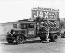
| Date: | 11 06 1933 |
|---|---|
| Description: | Men unloading barrels of Jax beer in front of the Ball Sandwich Stand in rural Louisiana. Jax beer was made by Jack's Brewing Company. |
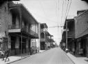
| Date: | |
|---|---|
| Description: | New Orleans street scene. Pedestrians can be seen on the sidewalks, and a streetcar can be seen in the distance. "Moskau Cabinet Works, door and window scr... |

| Date: | |
|---|---|
| Description: | From left to right, Sprague Vonier, Robert Bloch and Harold Gauer stand at the entrance to a bar called Regal in the French Quarter in New Orleans. |

| Date: | 1943 |
|---|---|
| Description: | Exterior view through trees of a store operated by Mattingly Tractor & Implement Company, an International Harvester dealership. |

| Date: | |
|---|---|
| Description: | View of cattle being driven down a street. Caption reads: "Street Scene, Covington, LA." |

| Date: | 1920 |
|---|---|
| Description: | Aerial view of the Baldwin Lumber Company, which sits next to a river. The main building consists of two long, rectangular structures that sit perpendicula... |

| Date: | 1995 |
|---|---|
| Description: | View towards an International model 3400 Commercial Bus parked in front of the Hotel de la Monnaie. The bus is white with red and blue stripes, with the "I... |

| Date: | 1759 |
|---|---|
| Description: | Map of New Orleans at the start of the French & Indian War, including two inset maps entitled "The Course of the Mississipi River from Bayagoulas to the Se... |

| Date: | 1769 |
|---|---|
| Description: | Map of New Orleans at the start of the French & Indian War, including two inset maps of the Mississippi River Delta and Fort la Balise. It shows streets, r... |

| Date: | 1761 |
|---|---|
| Description: | Map of New Orleans with north oriented towards the upper right corner. It shows the land around the city, the Mississippi River, anchorages, roads leading ... |
If you didn't find the material you searched for, our Library Reference Staff can help.
Call our reference desk at 608-264-6535 or email us at: