 Filter: Categories of Wisconsin Historical Images
Filter: State of Kentucky
Filter: Year of 1800-1899
Filter: Creator Name of Unknown
Filter: Categories of Wisconsin Historical Images
Filter: State of Kentucky
Filter: Year of 1800-1899
Filter: Creator Name of Unknown

| Date: | 11 26 1883 |
|---|---|
| Description: | A hand-drawn map of the Clinch and Powell's Valleys, including the Cumberland Mountains, Powell's Mountains and Clinch Mountains. |

| Date: | 1847 |
|---|---|
| Description: | A color map of Kentucky with insets showing Lexington, the Falls of Ohio, and the Ohio River. |
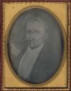
| Date: | 1850 |
|---|---|
| Description: | Quarter plate daguerreotype of a painting of Bland Ballard (1761-1853). Ballard was a noted Kentucky pioneer, and also served as a scout for General George... |
If you didn't find the material you searched for, our Library Reference Staff can help.
Call our reference desk at 608-264-6535 or email us at: