 Filter: Categories of Wisconsin Historical Images
Filter: State of Kentucky
Filter: Subject of maps
Filter: Categories of Wisconsin Historical Images
Filter: State of Kentucky
Filter: Subject of maps

| Date: | 1780 |
|---|---|
| Description: | Hand-drawn plan for the layout of the town of Clarksville, bordering Mayfield Creek and Liberty Creek. Fort Jefferson is shown between the townsite and the... |
| Date: | |
|---|---|
| Description: | Plat map of Mammoth Cave. A note on the map reads: "Mrs. Campbell conjectures that this is a saltpeter cave in Green River, Kentucky. The mummy found in it... |

| Date: | |
|---|---|
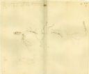
| Description: | A plat of Mammoth Cave with detailed descriptive annotations. |

| Date: | 1828 |
|---|---|
| Description: | Drawing by Increase Lapham showing the geological profile of the land between Utica and Knob Creek, Kentucky at a scale of 1/2 inch to a mile. |

| Date: | 1784 |
|---|---|
| Description: | Map showing fifty thousand acres of land in what will later become Kentucky, broken up into parcels labeled 1 through 50. No features are labeled, but the ... |
If you didn't find the material you searched for, our Library Reference Staff can help.
Call our reference desk at 608-264-6535 or email us at: