 Filter: Categories of Wisconsin Historical Images
Filter: State of Kentucky
Filter: Subject of arts
Filter: Categories of Wisconsin Historical Images
Filter: State of Kentucky
Filter: Subject of arts
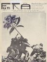
| Date: | 12 1968 |
|---|---|
| Description: | Cover of "Fun Travel Adventure," an underground newspaper, depicting a photomontage of soldiers at Iwo Jima with an oversized, purple flower replacing the ... |
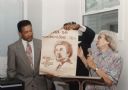
| Date: | |
|---|---|
| Description: | Anne Braden and Rev. Ben Chavis at an SOC (Southern Organizing Committee for Economic and Human Welfare) event. Braden and Chavis were founding members a... |

| Date: | 1906 |
|---|---|
| Description: | Low view of a bronze statue of Daniel Boone standing atop a pedestal of rough-hewn rocks. Leafy tree limbs form the backdrop. |

| Date: | 1922 |
|---|---|
| Description: | View of a statue of the Immaculate Conception. A man rows a boat toward the statue which stands in the water. A priest blesses the statue and two servers s... |

| Date: | |
|---|---|
| Description: | View of the abbey's facade, with the church's steeple visible behind and to the left of the monastery. A white picket fence with an iron gate entrance surr... |

| Date: | 11 1976 |
|---|---|
| Description: | A man is carrying a chair into a house from an International Harvester model 1700 truck owned by A. Arnold and Son Transfer & Storage Co. of Louisville, Ke... |

| Date: | 1831 |
|---|---|
| Description: | Map of the city of Louisville, Kentucky on the Ohio River showing streets and numbered lots. The Ohio River, Corn Island, and the Louisville and Portland C... |

| Date: | 1828 |
|---|---|
| Description: | Map of the Louisville and Portland Canal on the Ohio River. The map shows Louisville, Shippingsport, Clarksville, Jeffersonville, Gravel Island, Corn Islan... |
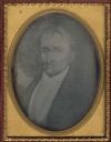
| Date: | 1850 |
|---|---|
| Description: | Quarter plate daguerreotype of a painting of Bland Ballard (1761-1853). Ballard was a noted Kentucky pioneer, and also served as a scout for General George... |

| Date: | 1795 |
|---|---|
| Description: | Detailed map of Kentucky and most of Tennessee. The map shows the borders, counties, cities, towns, Native American towns, forts, roads, mountains, lakes, ... |

| Date: | 1795 |
|---|---|
| Description: | Detailed map of Kentucky showing counties, cities, towns, Native American towns, forts, salt licks, roads, prairies, mountains, lakes, and rivers. Numerous... |

| Date: | 1793 |
|---|---|
| Description: | Detailed topographical map of the Ohio River between Clarkville and Louisville. It shows plots of farmland, forest, islands, garden plots, houses, Fort Fe... |

| Date: | |
|---|---|
| Description: | Waist-up profile portrait of Gen. James Ray of Kentucky. |
If you didn't find the material you searched for, our Library Reference Staff can help.
Call our reference desk at 608-264-6535 or email us at: