 Filter: Categories of Wisconsin Historical Images
Filter: State of Georgia
Filter: Subject of transportation
Filter: Year of 1800-1899
Filter: Categories of Wisconsin Historical Images
Filter: State of Georgia
Filter: Subject of transportation
Filter: Year of 1800-1899
| Date: | 1863 |
|---|---|
| Description: | Woodcut of Andersonville Prison from the "Report of the Andersonville Monument Commission." About 1863-1865. |
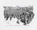
| Date: | 1864 |
|---|---|
| Description: | "Andersonville Prison, Camp Sumter, Ga., as it appeared August 1st 1864 when it contained 35,000 prisoners of war." |
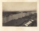
| Date: | 1866 |
|---|---|
| Description: | Elevated view over storefronts and the river. Plate 50 |
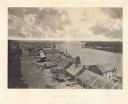
| Date: | 1866 |
|---|---|
| Description: | Elevated view over storefronts and the river. Plate 49 |
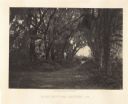
| Date: | 1866 |
|---|---|
| Description: | Trees with Spanish moss line a path in the Bonaventure Cemetery. Plate 48 |
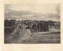
| Date: | 1866 |
|---|---|
| Description: | Elevated view of commercial area of the city, taken after General Sherman marched through. Most of the buildings appear to be intact, but one of the build... |
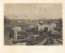
| Date: | 1866 |
|---|---|
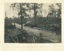
| Description: | Elevated view of the ruins of the railroad roundhouse, with the city in the background. Men are posing on the train cars and engines. Plate 45 |
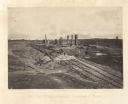
| Date: | 1864 |
|---|---|
| Description: | General Hood ordered a train full of gunpowder set on fire so that the Union Army couldn't use it, resulting in a series of explosions Plate 44 |

| Date: | 1866 |
|---|---|
| Description: | The south bank of the Chattahoochie River with a bridge spanning it. In the foreground are some battlements. Plate 33 |
| Date: | 1866 |
|---|---|
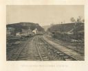
| Description: | View from railroad tracks through the Allatoona Pass. One of the buildings on the left says "Grocery," and piles of lumber are stacked along the sides of t... |
| Date: | 1866 |
|---|---|
| Description: | A dirt road passes through the battlefield, with fortifications on the sides. It is a lightly forested area. A horse and buggy are among some trees in the ... |
| Date: | 1866 |
|---|---|
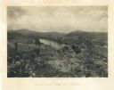
| Description: | View towards the Allatoona Pass from behind earthworks overlooking the Etawah River. A railroad bridge crosses the river on the right. Plate 24 |

| Date: | 1866 |
|---|---|
| Description: | View along earthworks overlooking the Etawah River and a railroad bridge. A tree stripped of branches and bark is on the left. Plate 23 |

| Date: | 1866 |
|---|---|
| Description: | View of earthworks at the battlefield at Resacca. Dirt roads cross the field in the distance, leading to a farm and what appears to be a river. Plate 22... |

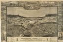
| Date: | 1864 |
|---|---|
| Description: | This map of the Atlanta area shows entrenchments, relief by hachures, vegetation, drainage, roads, railroads, towns, and the names of a few residents in th... |

| Date: | 1865 |
|---|---|
| Description: | Detailed map of the southeastern United States showing fortifications, "movements of Genl. J.H. Wilson's Cavalry Corps," "pursuit of Hood" and the lines of... |

| Date: | 1865 |
|---|---|
| Description: | This pen and ink map sketches the route taken by General Sherman's troops from Atlanta, Georgia, to Savannah, Georgia. Railroads, rivers, and towns are lab... |
If you didn't find the material you searched for, our Library Reference Staff can help.
Call our reference desk at 608-264-6535 or email us at: