 Filter: Categories of Wisconsin Historical Images
Filter: State of Georgia
Filter: Subject of rivers
Filter: Categories of Wisconsin Historical Images
Filter: State of Georgia
Filter: Subject of rivers
| Date: | |
|---|---|
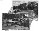
| Description: | A composite of two photographs depicting an ox cart and a Georgia ferry. The top photograph shows a small cable ferry crossing a river, carrying a horse-dr... |
| Date: | |
|---|---|
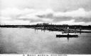
| Description: | View across water toward men standing and working on logs in the middle of the river. Booms help to collect the logs that are shipped down river from the f... |
| Date: | |
|---|---|
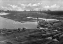
| Description: | Elevated view of two men standing on log booms which cover much of the river's surface. In the background are trees and a bridge. |

| Date: | |
|---|---|
| Description: | Two views, one of a ferry and the other of a chain gang. The ferry operator poses with a man in his carriage on the ferry, with trees in the background. Th... |
| Date: | 1866 |
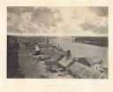
|---|---|
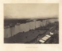
| Description: | Elevated view over storefronts and the river. Plate 50 |
| Date: | 1866 |
|---|---|
| Description: | Elevated view over storefronts and the river. Plate 49 |
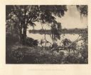
| Date: | 1866 |
|---|---|
| Description: | Trees with Spanish moss along the Savannah River. Plate 47 |

| Date: | 1866 |
|---|---|
| Description: | The south bank of the Chattahoochie River with a bridge spanning it. In the foreground are some battlements. Plate 33 |
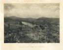
| Date: | 1866 |
|---|---|
| Description: | View towards the Allatoona Pass from behind earthworks overlooking the Etawah River. A railroad bridge crosses the river on the right. Plate 24 |

| Date: | 1866 |
|---|---|
| Description: | View along earthworks overlooking the Etawah River and a railroad bridge. A tree stripped of branches and bark is on the left. Plate 23 |

| Date: | 1866 |
|---|---|
| Description: | View of earthworks at the battlefield at Resacca. Dirt roads cross the field in the distance, leading to a farm and what appears to be a river. Plate 22... |

| Date: | 1865 |
|---|---|
| Description: | This pen and ink map sketches the route taken by General Sherman's troops from Atlanta, Georgia, to Savannah, Georgia. Railroads, rivers, and towns are lab... |

| Date: | 1779 |
|---|---|
| Description: | Map of colonial Georgia showing cities, towns, Native American land and towns, forts, roads, trading paths, islands, mountains, swamps, and rivers. Annotat... |

| Date: | 1795 |
|---|---|
| Description: | Map of Georgia, with its borders extending to the Mississippi River. It shows borders, various boundary lines, counties, cities, towns, Native American lan... |
If you didn't find the material you searched for, our Library Reference Staff can help.
Call our reference desk at 608-264-6535 or email us at: