 Filter: Categories of Wisconsin Historical Images
Filter: State of Georgia
Filter: Subject of railroads
Filter: Categories of Wisconsin Historical Images
Filter: State of Georgia
Filter: Subject of railroads

| Date: | 1919 |
|---|---|
| Description: | A bundled cotton bale rests on a wooden platform at a loading dock or train depot. A train car on a railroad track is alongside the right of the platform. |
| Date: | 1864 |
|---|---|
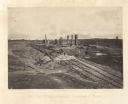
| Description: | General Hood ordered a train full of gunpowder set on fire so that the Union Army couldn't use it, resulting in a series of explosions Plate 44 |
| Date: | 1866 |
|---|---|
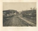
| Description: | View from railroad tracks through the Allatoona Pass. One of the buildings on the left says "Grocery," and piles of lumber are stacked along the sides of t... |

| Date: | 1866 |
|---|---|
| Description: | View along earthworks overlooking the Etawah River and a railroad bridge. A tree stripped of branches and bark is on the left. Plate 23 |
| Date: | 1910 |
|---|---|
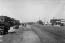
| Description: | Commercial buildings stand on either side of a set of railroad tracks. Automobiles line each street and the Toombs County Courthouse, featuring a colonnad... |

| Date: | 1864 |
|---|---|
| Description: | This map of the Atlanta area shows entrenchments, relief by hachures, vegetation, drainage, roads, railroads, towns, and the names of a few residents in th... |

| Date: | 1865 |
|---|---|
| Description: | Detailed map of the southeastern United States showing fortifications, "movements of Genl. J.H. Wilson's Cavalry Corps," "pursuit of Hood" and the lines of... |

| Date: | 1865 |
|---|---|
| Description: | This pen and ink map sketches the route taken by General Sherman's troops from Atlanta, Georgia, to Savannah, Georgia. Railroads, rivers, and towns are lab... |

| Date: | |
|---|---|
| Description: | This detailed map shows fortifications, headquarters, location and dates of battles, street outline of Atlanta, roads, railroads, vegetation, drainage, rel... |
If you didn't find the material you searched for, our Library Reference Staff can help.
Call our reference desk at 608-264-6535 or email us at: