 Filter: Categories of Wisconsin Historical Images
Filter: State of Georgia
Filter: Subject of mountains
Filter: Categories of Wisconsin Historical Images
Filter: State of Georgia
Filter: Subject of mountains
| Date: | 1866 |
|---|---|
| Description: | A fence or battlement, with battered trees overlooking a valley. Kenesaw Mountain is in the distance. |
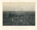
| Date: | 1866 |
|---|---|
| Description: | Earthworks in a field in foreground. In the middle distance is a small house with a fence. The Kenesaw Mountain is in the background. |
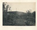
| Date: | 1866 |
|---|---|
| Description: | Pine Mountain with a lone, bare tree on top. Trees and shrubs are in the foreground. Plate 30 |
| Date: | 1866 |
|---|---|
| Description: | Two men stand on either side of an opening in the earthworks at Allatoona Pass. Mountains are in the distance. Plate 28 |
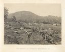
| Date: | 1866 |
|---|---|
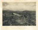
| Description: | View towards the Allatoona Pass from behind earthworks overlooking the Etawah River. A railroad bridge crosses the river on the right. Plate 24 |

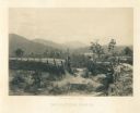
| Date: | 1866 |
|---|---|
| Description: | View along earthworks overlooking the Etawah River and a railroad bridge. A tree stripped of branches and bark is on the left. Plate 23 |
| Date: | 1866 |
|---|---|
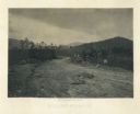
| Description: | View across road of one man sitting on a log, and another man lying on the ground near the opposite side of the road. Debris surrounds them, and in the bac... |

| Date: | 1779 |
|---|---|
| Description: | Map of colonial Georgia showing cities, towns, Native American land and towns, forts, roads, trading paths, islands, mountains, swamps, and rivers. Annotat... |

| Date: | 1795 |
|---|---|
| Description: | Map of Georgia, with its borders extending to the Mississippi River. It shows borders, various boundary lines, counties, cities, towns, Native American lan... |
If you didn't find the material you searched for, our Library Reference Staff can help.
Call our reference desk at 608-264-6535 or email us at: