Filter: Categories of Wisconsin Historical Images
Filter: State of Georgia
Filter: Subject of islands
Filter: Categories of Wisconsin Historical Images
Filter: State of Georgia
Filter: Subject of islands
| Date: | |
|---|---|
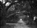
| Description: | A view looking down a dirt road, surrounded by large trees and smaller palm trees. |

| Date: | 1779 |
|---|---|
| Description: | Map of colonial Georgia showing cities, towns, Native American land and towns, forts, roads, trading paths, islands, mountains, swamps, and rivers. Annotat... |

| Date: | 1795 |
|---|---|
| Description: | Map of Georgia, with its borders extending to the Mississippi River. It shows borders, various boundary lines, counties, cities, towns, Native American lan... |
If you didn't find the material you searched for, our Library Reference Staff can help.
Call our reference desk at 608-264-6535 or email us at: