 Filter: Categories of Wisconsin Historical Images
Filter: State of Georgia
Filter: Subject of hills
Filter: Categories of Wisconsin Historical Images
Filter: State of Georgia
Filter: Subject of hills

| Date: | |
|---|---|
| Description: | A man standing in front of the old stone bank building of Cooper Iron Works. Caption reads: "Old Bank Building of Cooper Iron Works, Destroyed by Sherman's... |
| Date: | |
|---|---|
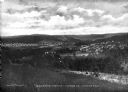
| Description: | Elevated view of Pepperell Manufacturing Company, manufacturers of sheets, including company town and surrounding countryside. Caption reads: "Bird's-Eye V... |

| Date: | |
|---|---|
| Description: | A view of Confederate breastworks, ridges in the hillsides for defense, at Western Heights. A fence divides the land in the foreground. Caption reads: "Con... |
| Date: | 1930 |
|---|---|
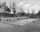
| Description: | A view of a swimming pool beside a hill at Bessie Tift College. Next to the pool is a vine-covered pergola and a slide. College buildings are visible in th... |
| Date: | 1866 |
|---|---|
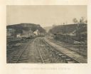
| Description: | View from railroad tracks through the Allatoona Pass. One of the buildings on the left says "Grocery," and piles of lumber are stacked along the sides of t... |

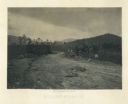
| Date: | 1866 |
|---|---|
| Description: | View of earthworks at the battlefield at Resacca. Dirt roads cross the field in the distance, leading to a farm and what appears to be a river. Plate 22... |
| Date: | 1866 |
|---|---|
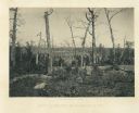
| Description: | Barren and battered trees on the Resacca battlefield. There is a house in a valley in the distance. Plate 21 |
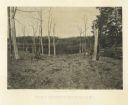
| Date: | 1866 |
|---|---|
| Description: | Trees stripped of bark. There is a fence on the right. In the far background is a building, perhaps a house, on a hill. Plate 19 |
| Date: | 1866 |
|---|---|
| Description: | View across road of one man sitting on a log, and another man lying on the ground near the opposite side of the road. Debris surrounds them, and in the bac... |
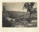
| Date: | 1866 |
|---|---|
| Description: | View of Ringgold in the far distance. A tree and pile of rubble, perhaps the remains of a fireplace, in the foreground. Plate 17 |
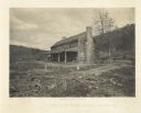
| Date: | 1866 |
|---|---|
| Description: | Farmhouse with a large chimney and front porch. A group of people are sitting on the porch. The house was used as a hospital several times during the battl... |

| Date: | 1779 |
|---|---|
| Description: | Map of colonial Georgia showing cities, towns, Native American land and towns, forts, roads, trading paths, islands, mountains, swamps, and rivers. Annotat... |

| Date: | 1950 |
|---|---|
| Description: | Subject: "TD-24 — Dams & Levees." Where Taken: "SE." Information with photograph reads: "TD-24 owned by Hardaway Co. of Columbus, Ga. at work on the Clark ... |
If you didn't find the material you searched for, our Library Reference Staff can help.
Call our reference desk at 608-264-6535 or email us at: