 Filter: Categories of Wisconsin Historical Images
Filter: State of Georgia
Filter: Subject of fortification
Filter: Categories of Wisconsin Historical Images
Filter: State of Georgia
Filter: Subject of fortification
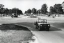
| Date: | 1964 |
|---|---|
| Description: | A man drives an International Harvester Scout past military vehicles on display near the entrance to Fort Stewart. |
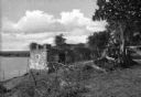
| Date: | |
|---|---|
| Description: | A view of the stone ruins of Fort Oglethorpe, erected in 1735. Trees frame the right side of the photograph, and a body of water is on the left. |
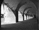
| Date: | 1938 |
|---|---|
| Description: | Light shines through the arches of a portico onto the walkway of Fort Pulaski, completed in 1847. |
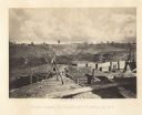
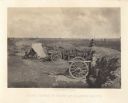
| Date: | 1864 |
|---|---|
| Description: | Confederate defenses surrounding the city. A tripod style configuration of rifles with a bag and canteen hanging from it is in the foreground. Plate 43<... |
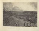
| Date: | 1864 |
|---|---|
| Description: | One of the Confederate defenses surrounding the city. This view is of the inside of the earthworks which includes two cannons. A Union soldier sits as a lo... |

| Date: | 1864 |
|---|---|
| Description: | One of the Confederate defenses around the city, with a cannon and earthworks in the foreground. Tents are in the background among trees. Plate 41 |

| Date: | 1864 |
|---|---|
| Description: | One of the Confederate defenses around the city, with several cannons behind earthworks. A Union soldier stands near one of the cannons. Plate 40 |

| Date: | 1864 |
|---|---|
| Description: | View looking out from one of the Confederate defenses around the outside of the city. Wooden palisades surround the earthworks. Houses and other buildings ... |
| Date: | 1866 |
|---|---|
| Description: | An empty battlefield with posts sticking out from an earthworks in the foreground. Plate 37 |

| Date: | 1866 |
|---|---|
| Description: | The south bank of the Chattahoochie River with a bridge spanning it. In the foreground are some battlements. Plate 33 |
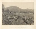
| Date: | 1866 |
|---|---|
| Description: | A fence or battlement, with battered trees overlooking a valley. Kenesaw Mountain is in the distance. |
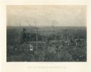
| Date: | 1866 |
|---|---|
| Description: | Earthworks in a field in foreground. In the middle distance is a small house with a fence. The Kenesaw Mountain is in the background. |
| Date: | 1866 |
|---|---|
| Description: | Two men stand on either side of an opening in the earthworks at Allatoona Pass. Mountains are in the distance. Plate 28 |
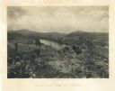
| Date: | 1866 |
|---|---|
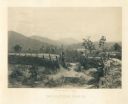
| Description: | View towards the Allatoona Pass from behind earthworks overlooking the Etawah River. A railroad bridge crosses the river on the right. Plate 24 |

| Date: | 1866 |
|---|---|
| Description: | View along earthworks overlooking the Etawah River and a railroad bridge. A tree stripped of branches and bark is on the left. Plate 23 |

| Date: | 1866 |
|---|---|
| Description: | View of earthworks at the battlefield at Resacca. Dirt roads cross the field in the distance, leading to a farm and what appears to be a river. Plate 22... |

| Date: | 1865 |
|---|---|
| Description: | Detailed map of the southeastern United States showing fortifications, "movements of Genl. J.H. Wilson's Cavalry Corps," "pursuit of Hood" and the lines of... |

| Date: | 1865 |
|---|---|
| Description: | This map shows fortifications, headquarters, and location and dates of battles. Relief is shown by hachures. A list of authorities is included. Blue lines ... |
If you didn't find the material you searched for, our Library Reference Staff can help.
Call our reference desk at 608-264-6535 or email us at: