 Filter: Categories of Wisconsin Historical Images
Filter: GENRE of Map or Atlas
Filter: Subject of signs and symbols
Filter: Categories of Wisconsin Historical Images
Filter: GENRE of Map or Atlas
Filter: Subject of signs and symbols

| Date: | 1889 |
|---|---|
| Description: | Illustration of the exterior of the Fuller Opera House, which is a detail from a bird's-eye view map of Madison. |

| Date: | 1893 |
|---|---|
| Description: | Bird's-eye map of Sturgeon Bay, looking Northeast. Area bordered by Church Street in top left corner, leather & Smith Bridge in bottom left corner, Lawrenc... |

| Date: | 1949 |
|---|---|
| Description: | Color bird's-eye map of the University of Wisconsin-Madison as it was midcentury, with two co-eds, several photographs of campus landmarks around edges, an... |

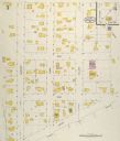
| Date: | 05 1926 |
|---|---|
| Description: | Section 1 of a Sanborn map of Osceola. |

| Date: | 05 1926 |
|---|---|
| Description: | Section 2 of a Sanborn map of Osceola. |
| Date: | 05 1926 |
|---|---|
| Description: | Section 3 of a Sanborn map of Osceola. |

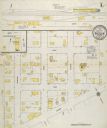
| Date: | 10 1911 |
|---|---|
| Description: | Section 1 of a Sanborn map of Osceola. |
| Date: | 10 1911 |
|---|---|
| Description: | Section 2 of a Sanborn Map of Osceola. |

| Date: | 1670 |
|---|---|
| Description: | This map is in French and shows Lac Tracy ov Superieur (Lake Superior), Baye des Puans (Green Bay), and portions of Lac des Ilinois (Lake Michigan) and Lac... |

| Date: | |
|---|---|
| Description: | Map reads: "Historic and Scenic Wisconsin — Land of Gathering Waters." In an inset there is a hand-painted depiction of the Wisconsin State Seal. For some ... |
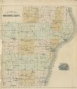
| Date: | 1878 |
|---|---|
| Description: | Outline map of Manitowoc County. Includes engraving of Wisconsin State Seal at bottom right. |

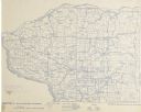
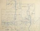
| Date: | 06 29 1941 |
|---|---|
| Description: | A map showing the national roots of the people of Wisconsin, based on the ethnic stock research by University of Wisconsin-Madison sociologist Prof. George... |

| Date: | 1896 |
|---|---|
| Description: | Section 3 of 12, this bicycle road map features Wisconsin bicycle routes in the counties of Winnebago, Calumet, Manitowoc, Outagamie, Brown, Kewaunee, and ... |
| Date: | 1896 |
|---|---|
| Description: | Section 4 of 12, this bicycle road map features Wisconsin bicycle routes in the counties of Iowa, Grant, and La Fayette. |

| Date: | 1896 |
|---|---|
| Description: | Section 6 of 12, this bicycle road map features Wisconsin bicycle routes in the counties of Wood, Portage, Waupaca, Washara, Juneau, and Adams. |
| Date: | 1896 |
|---|---|
| Description: | Section 9 of 12, this bicycle road map features Wisconsin bicycle routes in the counties of Taylor, Marathon, Lincoln, and Price. |
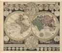
| Date: | 1745 |
|---|---|
| Description: | A two page world map featuring the Eastern and Western Hemispheres, as well as the northern and southern zodiacs. Additionally, the map is ordained with n... |

| Date: | |
|---|---|
| Description: | Map of Baraboo and its surroundings, showing the ancient mound city, the water power, and thoroughfares, drawn by William H. Canfield. Canfield includes sk... |
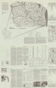
| Date: | 1976 |
|---|---|
| Description: | This is a guide to the original bikeway and additions. The front of the guide includes a map of Wisconsin, a map of the entire bikeway, and one route map. ... |

| Date: | 1861 |
|---|---|
| Description: | A general map of Pennsylvania, Virginia, New Jersey and Delaware. Insets include maps of New Orleans, Baltimore, St. Louis, Charleston, Savannah, Washingto... |
If you didn't find the material you searched for, our Library Reference Staff can help.
Call our reference desk at 608-264-6535 or email us at: