 Filter: Categories of Wisconsin Historical Images
Filter: GENRE of Map or Atlas
Filter: Subject of newspapers
Filter: Categories of Wisconsin Historical Images
Filter: GENRE of Map or Atlas
Filter: Subject of newspapers
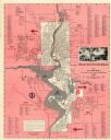
| Date: | 1954 |
|---|---|
| Description: | This map of Wausau is pink, red, gray, and white. The map includes indexes of streets, industries, and community buildings and features a photograph of the... |

| Date: | 1935 |
|---|---|
| Description: | This map shows streets, railroads, and city wards. Streets, the Oconto River, and the Green Bay are labeled. The bottom of the map reads: "Compliments of O... |

| Date: | 1903 |
|---|---|
| Description: | This map shows townships and sections, landownership and acreages, roads, railroads, and selected rural buildings. Townships and sections appear in yellow,... |
If you didn't find the material you searched for, our Library Reference Staff can help.
Call our reference desk at 608-264-6535 or email us at: