 Filter: Categories of Wisconsin Historical Images
Filter: GENRE of Map or Atlas
Filter: Subject of intellectual life
Filter: Categories of Wisconsin Historical Images
Filter: GENRE of Map or Atlas
Filter: Subject of intellectual life

| Date: | 1925 |
|---|---|
| Description: | A map of the farm planned by Edwin Bottomley in 1844. |

| Date: | 1865 |
|---|---|
| Description: | Map showing the location of meteorological stations and effects that Lake Michigan has had on Wisconsin temperatures in January and July. The map shows cou... |

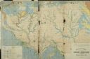
| Date: | 1904 |
|---|---|
| Description: | A map showing the design for a park fronting on Lake Monona Bay. (Now called Brittingham Park) taken from between pages 44 & 45 of the 1905 Madison Park a... |

| Date: | 1908 |
|---|---|
| Description: | Colored map in perspective indicates railroad routes. Lake Winnebago and Oshkosh in center, area extends to Shawano (top right corner), Green Bay (bottom r... |

| Date: | 12 26 1862 |
|---|---|
| Description: | Handsketched map of the area around Knobs Gap. |

| Date: | |
|---|---|
| Description: | Map of location of bones, used in bison excavation project. |

| Date: | 1673 |
|---|---|
| Description: | Facsimile of the autograph map of the Mississippi or Conception River drawn by Father Marquette at the time of his voyage. From the original preserved at S... |

| Date: | 1829 |
|---|---|
| Description: | Map of lead mines operating in Wisconsin. |

| Date: | 1857 |
|---|---|
| Description: | Plat map of Kekoskee, Wisconsin. Kekoskee is a village in Dodge County, in the Beaver Dam metropolitan area. The community name derives from Indian term fo... |
| Date: | 1860 |
|---|---|
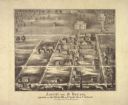
| Description: | Ansicht Von St Nanianz, gregundet vom Jahr 1854 bis 1860. Sr. Hochw. Hern V. Oschald. n.p., n.d. |
| Date: | 1917 |
|---|---|
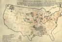
| Description: | United States map showing co-operative field work of the Agricultural Extension Department of the International Harvester Company from January of 1913 to J... |

| Date: | 07 04 1776 |
|---|---|
| Description: | Hand-drawn map of the area where the Battle of Black's Fort took place. |
| Date: | 06 1930 |
|---|---|
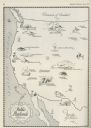
| Description: | A map of the western states showing "public playlands," mostly national parks. |
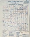
| Date: | |
|---|---|
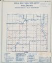
| Description: | Rural electrification survey map of Marquette county in Westfield township. |
| Date: | |
|---|---|
| Description: | Rural electrification survey map of Waushara county in Springwater township. |

| Date: | 1959 |
|---|---|
| Description: | University of Wisconsin-Madison campus. Numbers in circles identify buildings across campus with the building index. Black arrows point out important infor... |
| Date: | |
|---|---|
| Description: | Geological Map of the lead regions in Wisconsin, Illinois and Iowa. |
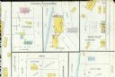
| Date: | 03 1904 |
|---|---|
| Description: | Detail of a Sanborn map of Grafton including the Sheboygan Knitting Company. |
If you didn't find the material you searched for, our Library Reference Staff can help.
Call our reference desk at 608-264-6535 or email us at:

