 Filter: Categories of Wisconsin Historical Images
Filter: GENRE of Map or Atlas
Filter: Subject of disasters
Filter: Categories of Wisconsin Historical Images
Filter: GENRE of Map or Atlas
Filter: Subject of disasters

| Date: | |
|---|---|
| Description: | Map of the district of the Peshtigo fire, approximately 1,280,000 acres, in Wisconsin and Upper Michigan. |

| Date: | 1875 |
|---|---|
| Description: | Bird's-eye map after a fire destroyed a large area of the town. In memory of the Great Conflagration on April 28th, 1875. Taken from the North-Side. |
| Date: | 1871 |
|---|---|
| Description: | Weather map depicting the great cyclonic storm that prevailed the day of the Peshtigo and Chicago fires. |

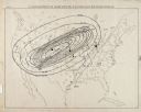
| Date: | 1907 |
|---|---|
| Description: | Topographic map of the Wisconsin River done under direction of Daniel Meade for construction of the Kilbourn dam by the Southern Wisconsin Power Company. I... |

| Date: | 1926 |
|---|---|
| Description: | This hand-colored blueprint map shows landowners in part of T15N, R5E in Juneau County. North is oriented to the right. |

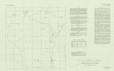
| Date: | 1916 |
|---|---|
| Description: | This version of a 1916 Wisconsin Conservation Commission map shows Peninsula State Park in the Town of Gibraltar, Door County, Wisconsin. Depicted are open... |
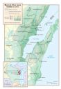
| Date: | 1999 |
|---|---|
| Description: | Map depicting the burned over area created by the fire on October 8, 1871. Map includes inset of Wisconsin and surrounding states with detail of area impac... |

| Date: | 1868 |
|---|---|
| Description: | This map of the state of Wisconsin was created in 1868 and later used by Increase Lapham to trace an outbreak of tornadoes going across the state in May of... |
| Date: | 1980 |
|---|---|
| Description: | This map shows earthquake data and includes text about tables, references, and the Modified Mercalli Intensity Scale of 1931. Table one lists earthquakes c... |
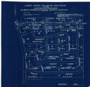
| Date: | 04 1958 |
|---|---|
| Description: | This blueprint map shows additions, sections, and streets. The upper left of the map reads: "Plan for 6ʺ watermain, hydrants & appurtenances." The up... |

| Date: | 1746 |
|---|---|
| Description: | Detailed map of the western hemisphere and part of Africa and Europe. Islands, cities, settlements, rivers, lakes, countries, and regions are marked. Mount... |
If you didn't find the material you searched for, our Library Reference Staff can help.
Call our reference desk at 608-264-6535 or email us at: