 Filter: Categories of Wisconsin Historical Images
Filter: GENRE of Map or Atlas
Filter: Subject of brickmaking
Filter: Categories of Wisconsin Historical Images
Filter: GENRE of Map or Atlas
Filter: Subject of brickmaking

| Date: | 1900 |
|---|---|
| Description: | This photostat of a manuscript map originally drawn in 1829 shows landownership, buildings, including Fort Howard and U.S. sawmill, swamps, public barns an... |
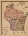
| Date: | 06 01 1900 |
|---|---|
| Description: | This map shows the the locations of different kinds of clay and shales throughout the state of Wisconsin. Includes a colored legend of types of clay and sh... |
If you didn't find the material you searched for, our Library Reference Staff can help.
Call our reference desk at 608-264-6535 or email us at: