 Filter: Categories of Wisconsin Historical Images
Filter: GENRE of Map or Atlas
Filter: County of Douglas
Filter: Year of 1900-1999
Filter: Year of 1920-1929
Filter: Categories of Wisconsin Historical Images
Filter: GENRE of Map or Atlas
Filter: County of Douglas
Filter: Year of 1900-1999
Filter: Year of 1920-1929
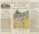
| Date: | 1922 |
|---|---|
| Description: | Wisconsin Geological and Natural History Survey soil map of Wisconsin supplemented by promotional materials about the County's prospects, schools and agric... |

| Date: | 1929 |
|---|---|
| Description: | "Compliments of the Douglas County Highway Department"--Top margin. Shows state-trunk highways, county highways, town roads, trails, boundaries, and concr... |

| Date: | 1925 |
|---|---|
| Description: | This map of Howard's Bay located at the Duluth Superior Harbor is a close view of Connors Point and shows a key to prevailing winds and water depth measure... |
If you didn't find the material you searched for, our Library Reference Staff can help.
Call our reference desk at 608-264-6535 or email us at: