 Filter: Categories of Wisconsin Historical Images
Filter: GENRE of Map or Atlas
Filter: County of Douglas
Filter: Subject of human settlements
Filter: Categories of Wisconsin Historical Images
Filter: GENRE of Map or Atlas
Filter: County of Douglas
Filter: Subject of human settlements

| Date: | 1883 |
|---|---|
| Description: | Bird's-eye map of Superior, county seat of Douglas County, on the shores of Lake Superior, with insets of points of interest. |

| Date: | 1890 |
|---|---|
| Description: | Bird's-eye view of Superior, Wisconsin. |

| Date: | 1913 |
|---|---|
| Description: | Bird's-eye map of Superior. "The New Steel Center." |

| Date: | 1915 |
|---|---|
| Description: | Bird's-eye view of Superior, Wisconsin, and Duluth, Minnesota on opposite shore of Lake Superior. |

| Date: | 1887 |
|---|---|
| Description: | Bird's-eye view of Superior, on Lake Superior. |

| Date: | 1890 |
|---|---|
| Description: | Bird's-eye map of West Superior and Superior, with insets of Wright Farm and First Building in Superior. |

| Date: | 1893 |
|---|---|
| Description: | Bird's-eye map of Superior. Looking from the point, with Superior Bay on left, St. Louis Bay on right, below St. Louis River. |
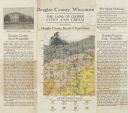
| Date: | 1922 |
|---|---|
| Description: | Wisconsin Geological and Natural History Survey soil map of Wisconsin supplemented by promotional materials about the County's prospects, schools and agric... |
| Date: | 1898 |
|---|---|
| Description: | Topographical map of the Brule River, with white print on blue paper. There is a portion of text on the map that reads "I hereby certify that the above map... |

| Date: | 1889 |
|---|---|
| Description: | This 1889 map of Douglas County, Wisconsin, shows the township and range grid, towns, sections, cities and villages, roads, existing and proposed railroads... |

| Date: | 1892 |
|---|---|
| Description: | This 1892 map of Douglas County, Wisconsin, shows the township and range grid, towns, sections, cities and villages, roads, railroads, trails, lakes and st... |

| Date: | 1899 |
|---|---|
| Description: | This 1899 map of Douglas County, Wisconsin, shows the township and range grid, towns, sections, cities, villages and railroad stations, mines, roads, railr... |

| Date: | 1911 |
|---|---|
| Description: | This map, taken from the 1911 Map of Wisconsin showing geology and roads by Hotchkiss and Thwaites, shows the northwest portion of Douglas County, Wisconsi... |

| Date: | 1914 |
|---|---|
| Description: | This 1914 map of Douglas County, Wisconsin, shows the township and range grid, towns, sections, cities and villages, roads, railroads, Indian trails, schoo... |

| Date: | 1943 |
|---|---|
| Description: | Shows portage trail, monuments, and hydrography in part of Solon Springs township, Douglas County, Wis. "All sections are in T45N, R11W." |

| Date: | 1953 |
|---|---|
| Description: | This is a detailed map of Douglas County, Wisconsin, showing townships and township borders, numbered wards, roadways, and bodies of water. There are annot... |

| Date: | 1890 |
|---|---|
| Description: | This map of Douglas County, Wisconsin, published around the beginning of the 20th century shows the copper bearing formations in the county on a map that a... |

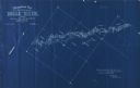
| Date: | 1800 |
|---|---|
| Description: | This pen and ink drawing with watercolor shows the course of the Black River from Rock Creek, near Greenwood in Clark County, Wisconsin, to its confluence ... |

| Date: | 1896 |
|---|---|
| Description: | This 1896 map of Douglas County, Wisconsin, shows the township and range grid, the towns of Superior, Brule, Gordon, and Nebagamain, sections, cities and v... |

| Date: | 1930 |
|---|---|
| Description: | Shows county system of roads which are surfaced, well graded, common, or unimproved, town roads, state trunk highways, town and village boundaries, schools... |
If you didn't find the material you searched for, our Library Reference Staff can help.
Call our reference desk at 608-264-6535 or email us at: