 Filter: Categories of Wisconsin Historical Images
Filter: GENRE of Map or Atlas
Filter: County of Dane
Filter: Categories of Wisconsin Historical Images
Filter: GENRE of Map or Atlas
Filter: County of Dane

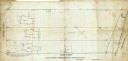
| Date: | 1880 |
|---|---|
| Description: | This map is pen-and-ink on paper. The map shows buildings, trees, and water and gas pipes, relief is shown by contours. The back of the map reads: "Univers... |
| Date: | 09 1886 |
|---|---|
| Description: | This map shows buildings with dimensions, as well as lot and block corners. Ink on tracing cloth. Oriented with north to the lower right. |

| Date: | 1887 |
|---|---|
| Description: | Shows pipes of various sizes, hydrants with hydrant pressure, valves, wells, and projected lines. |

| Date: | 1888 |
|---|---|
| Description: | Shows ward divisions and street railways, as well as University of Wisconsin buildings, churches, and schools. Cataloged from copy with right and left edge... |

| Date: | 1892 |
|---|---|
| Description: | Shows pipes of various sizes, hydrants with hydrant pressure, valves, wells, and projected lines. Differs from earlier versions by inclusion of Wingra Park... |

| Date: | 1896 |
|---|---|
| Description: | Shows pipes of various sizes, hydrants with hydrant pressure, valves, wells, projected lines, and suction pipes. Differs from earlier versions by inclusion... |

| Date: | 1898 |
|---|---|
| Description: | Shows landownership, buildings, and railroads. Lake Mendota and Lake Wingra are labelled. |

| Date: | 1903 |
|---|---|
| Description: | Shows lot numbers and dimensions. "Issued May 31, 1903" -- Inscribed in ink. Oriented with north to the upper right. Includes text. Labelled streets are "R... |

| Date: | 1903 |
|---|---|
| Description: | This map is ink on printed paper reading: "standard profile plate." "Surveyed Oct. 15, platted Dec. 15, 1903 ; surveyed May 9, platted Dec. 9." |

| Date: | 1904 |
|---|---|
| Description: | This map shows numbered wards and plots, labelled streets, and parks in green. |

| Date: | 1905 |
|---|---|
| Description: | This map shows roads, railroads, and location of Keyes Springs, now part of Monona. The map reads: "L.S. Smith, c.e., del. May, 1905" and "For further info... |

| Date: | 1906 |
|---|---|
| Description: | This map is pen-and-ink on paper. The relief is shown by contours and spot heights. "5’ contours." Includes area table. |

| Date: | 1907 |
|---|---|
| Description: | Shows public buildings, hotels, fraternity houses, and private houses. Index of fraternities and sororities, residences, public buildings, hotels, places o... |
| Date: | 06 08 1908 |
|---|---|
| Description: | Pen-and-ink on paper. Shows vicinity of Washburn Observatory and University Hall at the University of Wisconsin-Madison. Relief shown by contours and spot ... |

| Date: | 1908 |
|---|---|
| Description: | The map reads: "Feb. 3, 1908." Oriented with north to the lower left. Lake Monona, Monona Bay, and Brittingham Park are labelled. |

| Date: | 1908 |
|---|---|
| Description: | Shows pipes of various sizes, hydrants, valves, and wells. "1907" -- Lower margin. Lake Wingra, Lake Monona, and Lake Mendota are labelled. |

| Date: | 1909 |
|---|---|
| Description: | Streets, Lake Wingra, Lake Mendota, and Lake Monona are all labelled. Map reads: "The present park system of Madison comprises 150 acres of improved parks,... |

| Date: | 1910 |
|---|---|
| Description: | Shows existing and proposed parks, railroads, and marshes in a color coded key. "Contour interval 20 feet." Lake Wingra, Lake Mendota, and Lake Monona are ... |

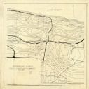
| Date: | 1920 |
|---|---|
| Description: | Shows wards and selected points of interest. Includes street index. Oriented with north to upper right. |
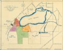
| Date: | 1920 |
|---|---|
| Description: | This map shows an arboretum and wildlife refuge in Madison, Wisconsin. There are color coded parcels "F" through "K" with acreages, as well as area around ... |
If you didn't find the material you searched for, our Library Reference Staff can help.
Call our reference desk at 608-264-6535 or email us at: