Filter: Categories of Wisconsin Historical Images
Filter: GENRE of Map or Atlas
Filter: County of Dane
Filter: Creator Name of Unknown
Filter: Categories of Wisconsin Historical Images
Filter: GENRE of Map or Atlas
Filter: County of Dane
Filter: Creator Name of Unknown

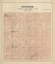
| Date: | 1873 |
|---|---|
| Description: | Map of the township of Windsor, from the "Atlas of Dane County." |

| Date: | 1861 |
|---|---|
| Description: | Drawn the first year of the Civil War, this colored 1861 map of Dane County shows its towns, cities and lakes. It includes insets of the wards of Madison a... |

| Date: | 1876 |
|---|---|
| Description: | Bird's-eye view of Black Earth. |

| Date: | 1910 |
|---|---|
| Description: | Map of Dane County rural delivery in Madison and the town of Westport. |

| Date: | 1836 |
|---|---|
| Description: | Map of all Dane County and eastern towns. |

| Date: | 1839 |
|---|---|
| Description: | A map of the Wiskonsin [sic] and Neenah or Fox Rivers. |

| Date: | 1916 |
|---|---|
| Description: | Map of all automobile roads out of Madison, compliments of the Madison Board Of Commerce. |

| Date: | 1910 |
|---|---|
| Description: | Map of the general plan of the district of the Four Lakes. |

| Date: | 1876 |
|---|---|
| Description: | Bird's-eye view of Middleton with an inset of a school house. |

| Date: | 1836 |
|---|---|
| Description: | The top map is the "Plat of Madison the Capitol of Wisconsin." The bottom map is the "Map of the Four Lake Country. Taken from the Township Maps in the U.S... |

| Date: | 1889 |
|---|---|
| Description: | Illustration of the exterior of the Fuller Opera House, which is a detail from a bird's-eye view map of Madison. |

| Date: | 1870 |
|---|---|
| Description: | Bird's-eye map of Madison. The Lakeside House resort is in the foreground, which burned in 1877, in what is now Olin Park. |
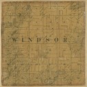
| Date: | 1861 |
|---|---|
| Description: | Dane County plat map of the town of Windsor. |

| Date: | 1911 |
|---|---|
| Description: | Plat Map of Blooming Grove in "Atlas of Dane County, Wisconsin." |

| Date: | 1920 |
|---|---|
| Description: | A map of Madison and the vicinity. Red lines show the street railway. |

| Date: | 1856 |
|---|---|
| Description: | Isthmus of Madison, including Lake Mendota, or Great Lake, and Lake Menona [sic]. |

| Date: | 07 01 1836 |
|---|---|
| Description: | Original plat map of the town of Madison on the four lakes. |

| Date: | 1855 |
|---|---|
| Description: | Map of Madison and surrounding communities, referred to as the four lakes country. Text bordering the map includes an excerpt of a letter written by Horace... |
If you didn't find the material you searched for, our Library Reference Staff can help.
Call our reference desk at 608-264-6535 or email us at: