 Filter: Categories of Wisconsin Historical Images
Filter: GENRE of Map or Atlas
Filter: County of Brown
Filter: Categories of Wisconsin Historical Images
Filter: GENRE of Map or Atlas
Filter: County of Brown

| Date: | 1961 |
|---|---|
| Description: | This map shows established harbor lines, local streets, railroads, U.S. government channel, and part of Fox River. The map includes a table of reference po... |

| Date: | 1987 |
|---|---|
| Description: | This map pictorially shows local roads, local businesses with phone numbers, and parts of Fox River and bay of Green Bay. |

| Date: | 1918 |
|---|---|
| Description: | This map shows railroads, street car lines, wards, private claims, parks, railroad yards and depots, and cemeteries. The map is oriented with north to uppe... |

| Date: | 1931 |
|---|---|
| Description: | This map shows streets and highways, street car and bus lines, railroads, depots, schools, wards, and points of interest. The map is oriented with the nort... |

| Date: | 1946 |
|---|---|
| Description: | This map shows streets, wards and precincts, parks, schools, and points of interest. The map is oriented with north to the upper left. The map includes a s... |

| Date: | 1950 |
|---|---|
| Description: | This map shows portions of highway remaining unchanged, proposed relocations, connecting county trunk roads existing or proposed, existing arterials, and e... |

| Date: | 1951 |
|---|---|
| Description: | This map has depths shown by bathymetric tints and soundings and relief shown by contours, the depths are shown in feet. There is an inset map of Green Bay... |
| Date: | 1956 |
|---|---|
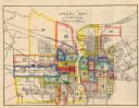
| Description: | This map shows streets and railroads and is oriented with north to the upper left. Wards have been outlined in yellow, red, blue, and green. The back of th... |

| Date: | 1800 |
|---|---|
| Description: | This map shows plat of the town, local streets, plank roads, and part of the Fox River. The bottom of the map includes annotations, probably in pencil. |

| Date: | 1914 |
|---|---|
| Description: | This map has relief shown by hachures and shows local streets, wards, districts, railroads, Fox River, and part of Bay of Green Bay. Wards are shown in dar... |
| Date: | 1961 |
|---|---|
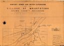
| Description: | This map shows a sewage treatment plant site and includes an index of "Title and Index," "Watermain Details," "Sanitary Sewer Details," and "Plan B Profile... |
| Date: | 1935 |
|---|---|
| Description: | This map is a photocopy and shows landownership and acreages, additions to Green Bay, points of interest, roads, and railroads. Hand annotations of green,... |

| Date: | 1874 |
|---|---|
| Description: | This map shows streets, buildings, railroads, the Fox River, the East River, and part of Green Bay. |
| Date: | 01 1935 |
|---|---|
| Description: | This map shows landownership and acreages, additions to Green Bay, roads, railroads, East River, and Fox River. The bottom left of the map reads: "January ... |

| Date: | 1963 |
|---|---|
| Description: | This blue line print shows as of March 1960 federal, state, county, and town roads, as well as railroads, schools, churches, town hall, parks, and Brown Co... |

| Date: | 1906 |
|---|---|
| Description: | This map shows streets, railroads, land use, public buildings, commercial businesses, and the Menominee River. Depths are shown by gradient tints and sound... |

| Date: | 1888 |
|---|---|
| Description: | This is a reproduction of a map originally published in 1829 by R.W. Chandler, a pioneer settler of Galena. It is based on an earlier map by surveyor Luciu... |

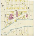
| Date: | 1907 |
|---|---|
| Description: | Sanborn map of Green Bay including St. George and Main Streets. |
| Date: | 1907 |
|---|---|
| Description: | A Sanborn map of Green Bay, prominently featuring the East River. |

| Date: | 1907 |
|---|---|
| Description: | Sanborn map of Green Bay featuring Elm, Cedar and Main Streets. |
If you didn't find the material you searched for, our Library Reference Staff can help.
Call our reference desk at 608-264-6535 or email us at: