 Filter: Categories of Wisconsin Historical Images
Filter: GENRE of Map or Atlas
Filter: County of Brown
Filter: Year of 1900-1999
Filter: Year of 1940-1949
Filter: Categories of Wisconsin Historical Images
Filter: GENRE of Map or Atlas
Filter: County of Brown
Filter: Year of 1900-1999
Filter: Year of 1940-1949
| Date: | 1947 |
|---|---|
| Description: | Map shows land ownership, residential zones, commercial zones, and light industrial zones. Includes inset and location map. Also includes zoning ordinance ... |

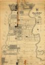
| Date: | 1946 |
|---|---|
| Description: | This map shows streets, wards and precincts, parks, schools, and points of interest. The map is oriented with north to the upper left. The map includes a s... |

| Date: | 04 11 1940 |
|---|---|
| Description: | This blue line print map shows survey monument markers by type and industrial buildings and covers part of the lower Fox River and East River. The map incl... |
If you didn't find the material you searched for, our Library Reference Staff can help.
Call our reference desk at 608-264-6535 or email us at: