 Filter: Categories of Wisconsin Historical Images
Filter: GENRE of Map or Atlas
Filter: Community of Racine
Filter: Year of 1900-1999
Filter: Subject of cities and towns
Filter: Categories of Wisconsin Historical Images
Filter: GENRE of Map or Atlas
Filter: Community of Racine
Filter: Year of 1900-1999
Filter: Subject of cities and towns

| Date: | 1972 |
|---|---|
| Description: | This map on 5 sheets features a title page sheet with business directory and shows section numbers, roads, railroads, saw mills, churches, blacksmith shops... |

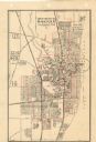
| Date: | 1903 |
|---|---|
| Description: | Map shows location of government buildings, schools, churches, parks, and other points of interest. The upper left hand margin features a "Reference" secti... |

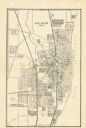
| Date: | 1921 |
|---|---|
| Description: | This map of Racine is oriented with north to the right and shows labeled streets, Lake Michigan, and points of interest. There are manuscript annotations i... |
| Date: | 1947 |
|---|---|
| Description: | This map of Racine has labeled streets, the Root River, Lake Michigan, and includes manuscript annotations of newly annexed areas and African-American neig... |

| Date: | 1956 |
|---|---|
| Description: | This map of Racine includes a street directory and index of public buildings. Streets, points of interest, Lake Michigan, and the Root River are labeled. A... |

| Date: | 1950 |
|---|---|
| Description: | This map of Racine's business section is oriented with the north to the right and shows businesses and lot owners. Businesses, streets, and the Root River ... |

| Date: | 1951 |
|---|---|
| Description: | This map of Racine Harbor has relief shown by contours and depths shown by gradient tints and soundings in feet. The map also shows Racine Reef, Wind Point... |
| Date: | 1950 |
|---|---|
| Description: | This map shows streets and waterways and includes annotations in red outlining wards. |

| Date: | 1935 |
|---|---|
| Description: | This map includes an index on the right margin of industrial plants, churches, schools, and public buildings. Streets, the Rock River, Lake Michigan, parks... |

| Date: | 1904 |
|---|---|
| Description: | This map is mounted on cloth and shows streets, railways, and city wards. A stamp in the right margin reads: "The Library of Congress, one copy received Fe... |

| Date: | 01 18 1907 |
|---|---|
| Description: | This map shows Lake Michigan, streets, schools, churches, businesses, cemeteries, parks, and railroads. Relief is shown by contours; depths are shown by so... |
| Date: | 1900 |
|---|---|
| Description: | This map shows plots and streets as well at the Root River. The bottom margin and back of the map include extensive certifications. |

| Date: | 1921 |
|---|---|
| Description: | This map shows selected streets, public buildings, churches, schools, businesses, warehouses, the harbor, the Root River, and Lake Michigan. The map includ... |
If you didn't find the material you searched for, our Library Reference Staff can help.
Call our reference desk at 608-264-6535 or email us at: