 Filter: Categories of Wisconsin Historical Images
Filter: GENRE of Map or Atlas
Filter: Community of Milwaukee
Filter: Year of 1900-1999
Filter: Categories of Wisconsin Historical Images
Filter: GENRE of Map or Atlas
Filter: Community of Milwaukee
Filter: Year of 1900-1999

| Date: | 1927 |
|---|---|
| Description: | Color map, hand-drawn with comic figures engaged in various activities throughout map. Bordered by the river on the left and Lake Michigan on the right, in... |

| Date: | 1906 |
|---|---|
| Description: | Polyconic projection. Map made from surveys without spirit level control. Henry Gannett, Chief Topographer. Topography by Van H. Manning and Nat. Tyler, Jr... |

| Date: | 1908 |
|---|---|
| Description: | Colored map in perspective indicates railroad routes. Lake Winnebago and Oshkosh in center, area extends to Shawano (top right corner), Green Bay (bottom r... |

| Date: | 1955 |
|---|---|
| Description: | Bottom of the map reads: "PARKING AREA STUDY MILWAUKEE COUNTY ZOOLOGICAL GARDEN SCALE 1"=200" APRIL 21, 1955 TOTAL PARKING AREA - 3736 CARS 31.1 acres". Th... |

| Date: | 1972 |
|---|---|
| Description: | These maps show the Milwaukee County supervisory districts as of April 1972 and the Supervisor and Assembly districts in effect prior to the April 1972 ele... |

| Date: | 1966 |
|---|---|
| Description: | This map from the 1960s provides a detailed street map of Milwaukee County and eastern Waukesha County as far west as Menomonee Falls and Muskego Lake. A p... |

| Date: | 1902 |
|---|---|
| Description: | A map of Milwaukee County, Wisconsin that shows the township and range system, sections, towns, roads, railroads and rail stations, cities and villages, po... |

| Date: | 1922 |
|---|---|
| Description: | A bird's-eye map that shows the Milwaukee Parkway as contemplated by the Milwaukee County Planning Commission. The map identifies the roads and parks throu... |

| Date: | 1968 |
|---|---|
| Description: | A tourist map of Milwaukee County and of downtown Milwaukee. The Map of Milwaukee County identifies the location of some of the points of interests in the ... |

| Date: | 1914 |
|---|---|
| Description: | A hand-drawn and colored map of the Milwaukee Township, showing how lands were used, included are parks, cemeteries, private grounds, and speculative land.... |

| Date: | 05 1958 |
|---|---|
| Description: | Photocopy of a map created by the City of Milwaukee Master Plan Program City Planning Division in May of 1958 representing 1870 "THE CENTRAL AREA OF THE CI... |
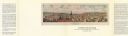
| Date: | 1976 |
|---|---|
| Description: | Bird’s-eye-view map. Contains labeled points of interest below the map describing the buildings and streets. Caption below the map reads: "CITIES ON STONE ... |

| Date: | 1902 |
|---|---|
| Description: | Map reads: "Milwaukee's Polish Population. Map showing in Red Color the Location and Density of Polish=Speaking Population of the City of Milwaukee, Wis." ... |

| Date: | 1911 |
|---|---|
| Description: | Map printed in the Milwaukee Herald, 16th of February, 1912. Includes list of Assembly, State Senate, and Congressional districts in bottom margin. Contain... |

| Date: | 1931 |
|---|---|
| Description: | This map is an advertisement for Milwaukee street cars and motor buses and reads: "Ride the street car or motor bus. Economical, safe, dependable." Include... |

| Date: | 1934 |
|---|---|
| Description: | Map showing the ward boundaries of Milwaukee. Each ward is numbered and boundary streets are labelled. The bottom right corner reads: "CITY ENGINEER'S DEPT... |

| Date: | 1950 |
|---|---|
| Description: | This map is accompanied by booklet: "Know Milwaukee Map and Street Guide". The map is a detailed map of Milwaukee and the surrounding suburbs. Streets and ... |
| Date: | 12 23 1949 |
|---|---|
| Description: | Typed and printed ink on paper. Map lists and shows suburbs in 1940. Map reads: "Milwaukee Metropolitan district in 1940. Pub. in Bayrd Still’s Milwaukee, ... |

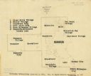
| Date: | 1940 |
|---|---|
| Description: | This map is pen and ink on paper and is 1 map consisting of 12 sheets. This map includes a numbered key labeling each area, all of which are represented ... |

| Date: | 1940 |
|---|---|
| Description: | Shows Milwaukee and Waukesha counties, and parts of Dodge, Washington, Ozaukee, Jefferson, Walworth, and Racine counties. Includes indexes of "Cities, Town... |
If you didn't find the material you searched for, our Library Reference Staff can help.
Call our reference desk at 608-264-6535 or email us at: