 Filter: Categories of Wisconsin Historical Images
Filter: GENRE of Drawing
Filter: Year of 1700-1799
Filter: Categories of Wisconsin Historical Images
Filter: GENRE of Drawing
Filter: Year of 1700-1799
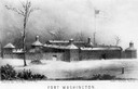
| Date: | 1790 |
|---|---|
| Description: | Fort Washington, built in 1789, where Cincinnati now stands. |

| Date: | 1780 |
|---|---|
| Description: | Hand-drawn plan for the layout of the town of Clarksville, bordering Mayfield Creek and Liberty Creek. Fort Jefferson is shown between the townsite and the... |

| Date: | 1780 |
|---|---|
| Description: | Plan for layout of 150,00 acres which make up Clark's Illinois Grant. |

| Date: | 1745 |
|---|---|
| Description: | A two page illustration featuring a small globe in the center of numerous astrological spheres. Additionally, the representation features writing, in Lati... |
If you didn't find the material you searched for, our Library Reference Staff can help.
Call our reference desk at 608-264-6535 or email us at:
