 Filter: Categories of Wisconsin Historical Images
Filter: GENRE of Drawing
Filter: Year of 1800-1899
Filter: Year of 1850-1859
Filter: Categories of Wisconsin Historical Images
Filter: GENRE of Drawing
Filter: Year of 1800-1899
Filter: Year of 1850-1859

| Date: | 10 1852 |
|---|---|
| Description: | Landscape view of the river looking downstream from Fort Snelling, Minnesota Territory. An expanse of placid river water fills the center of the drawing an... |
| Date: | 1851 |
|---|---|
| Description: | A watercolor view of Madison. Prominent on the left side of King Street is the Madison Hotel. |

| Date: | 1852 |
|---|---|
| Description: | Illustration of four Indians on Madeline Island with a canoe in the water on the shore. |

| Date: | 1852 |
|---|---|
| Description: | An illustration of a storm encountered by a delegation of Indians on their way to Washington, D.C. |
| Date: | 1856 |
|---|---|
| Description: | The Wisconsin State Capitol (the second State Capitol, the first in Madison). Illustration from the American Encyclopedia, Columbus, 1859. |

| Date: | 1850 |
|---|---|
| Description: | Elevated view of the Lake Superior shoreline, with terraces leading to the beach. A canoe is on the shoreline. |

| Date: | 1850 |
|---|---|
| Description: | Pastoral scene depicting a small bay on the Island of St. Ignace in Lake Superior with canoes on the rocky beach, two men conversing on a blanket in the fo... |

| Date: | 1850 |
|---|---|
| Description: | Pic Island on the north shore of Lake Superior. |

| Date: | 1855 |
|---|---|
| Description: | Detail from a lithograph vignette on a Map of the City of Madison of the third Wisconsin State Capitol, the first Capitol in Madison. |
| Date: | 1850 |
|---|---|
| Description: | Chippewa Indian Sugar Camp. Plate 61, preceding p. 199, vol. I, The Indian tribes of the United States: their history antiquities, customs, religion, ar... |
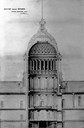
| Date: | 1857 |
|---|---|
| Description: | Section drawing of the rotunda of the third Wisconsin State Capitol (second in Madison) by Stephen V. Shipman. August Kutzbock and Samuel H. Donnel were th... |
| Date: | 1858 |
|---|---|
| Description: | Panoramic sketch of State Street between North and South Halls on the University of Wisconsin-Madison campus. Published in Frank Leslie's Illustrate Newsp... |
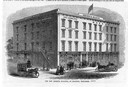
| Date: | 1853 |
|---|---|
| Description: | Illustration of the new museum building, also known as "Bruen's Block," on the corner of East Washington Avenue and South Pinckney Street. Named for W.D. B... |
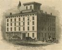
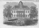
| Date: | 1853 |
|---|---|
| Description: | Illustration of the Capital house, a first-class hotel, copied from page 320 of Gleason's Pictorial Drawing-Room Companion. |

| Date: | 1852 |
|---|---|
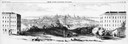
| Description: | Pencil drawing of Madison landscape as seen from University Hill. The main street in the center is State Street, and the building with Greek columns in the... |

| Date: | 1852 |
|---|---|
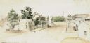
| Description: | Pencil drawing of view overlooking Madison. The sketch looks down North Hamilton Street from the capitol. Rutted, irregular streets and frame houses mark ... |

| Date: | 1854 |
|---|---|
| Description: | Drawing of the Porcupine Mountains on Lake Superior. A deer is standing in the lake drinking water. A man is on the rock ledge above the shoreline and is a... |
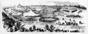
| Date: | 11 20 1858 |
|---|---|
| Description: | Panoramic sketch of the first Wisconsin State Fair held in Madison with large tents, fire companies, side-shows, and performances that drew thousands of vi... |
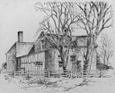
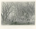
| Date: | 1850 |
|---|---|
| Description: | Strang House, also called "Mormon House," where "King" Strang lived and died, and where he published the Voree Herald. |
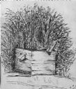
| Date: | 1850 |
|---|---|
| Description: | Black and white ink drawing of an old wooden well. |
If you didn't find the material you searched for, our Library Reference Staff can help.
Call our reference desk at 608-264-6535 or email us at: