Filter: Categories of Wisconsin Historical Images
Filter: GENRE of Drawing
Filter: Year of 1800-1899
Filter: Year of 1830-1839
Filter: Categories of Wisconsin Historical Images
Filter: GENRE of Drawing
Filter: Year of 1800-1899
Filter: Year of 1830-1839

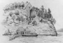
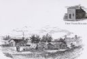
| Date: | 1834 |
|---|---|
| Description: | Peck-a-ton-oka (Pecatonica River) with Rodolf farm in the background. |
| Date: | 1833 |
|---|---|
| Description: | Illustration of the Solomon Juneau fur trading post at Milwaukee in 1833. |

| Date: | 07 1838 |
|---|---|
| Description: | A map diagram of Indian effigy mounds seven miles east of Blue Mounds in the Wisconsin Territory. |
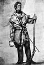
| Date: | 1834 |
|---|---|
| Description: | Full-length illustration of Henry Dodge in frontiersman attire. He is holding a hat, a gun, and has a sword on his belt. |
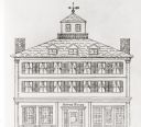
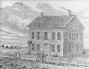
| Date: | 1838 |
|---|---|
| Description: | Pencil sketch of a building owned by the Rodolf family along a commercial street. |
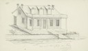
| Date: | 1838 |
|---|---|
| Description: | Pencil sketch of a stone house with a porch the full length of the dwelling, supported by 6 columns. |
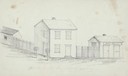
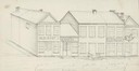
| Date: | 1838 |
|---|---|
| Description: | Pencil sketch of buildings, including the Post Office. |
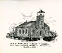
| Date: | 1835 |
|---|---|
| Description: | Drawing of the Stockbridge Indian Mission, built in about 1834. |
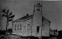
| Date: | 1835 |
|---|---|
| Description: | Drawing of the Stockbridge Indian mission. |

| Date: | 1836 |
|---|---|
| Description: | Woodcut of Prairie du Chien in 1836. Text at bottom reads: "Prairie du Chien in 1836. From an old cut." |

| Date: | 1830 |
|---|---|
| Description: | Drawing of the Astor building. Caption reads: "Astor Building in 1830 Main Village Lot Prairie•du•Chien". |
| Date: | 1836 |
|---|---|
| Description: | Drawing of the Solomon Juneau house on East Michigan. There are tethered bears on either side of the front door. Two people are leaning on the fence, watch... |

| Date: | 1837 |
|---|---|
| Description: | Copy of N.F. Hyer's original map of Aztalan as published in the Milwaukee Advertiser, February 25, 1837. |
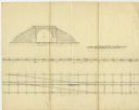
| Date: | 02 15 1830 |
|---|---|
| Description: | Increase Lapham's drawing of a railroad tunnel and railroad tracks. |

| Date: | 12 22 1830 |
|---|---|
| Description: | Increase Lapham's drawing of the geological profile between the Sandusky plains and Portsmouth, Ohio. |
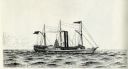
| Date: | 1834 |
|---|---|
| Description: | Drawing of the Great Lakes steamer Thomas Jefferson. |
If you didn't find the material you searched for, our Library Reference Staff can help.
Call our reference desk at 608-264-6535 or email us at: