 Filter: Categories of Wisconsin Historical Images
Filter: GENRE of Drawing
Filter: Year of 1800-1899
Filter: Categories of Wisconsin Historical Images
Filter: GENRE of Drawing
Filter: Year of 1800-1899

| Date: | 1850 |
|---|---|
| Description: | Elevated view of the Lake Superior shoreline, with terraces leading to the beach. A canoe is on the shoreline. |

| Date: | 1850 |
|---|---|
| Description: | Pastoral scene depicting a small bay on the Island of St. Ignace in Lake Superior with canoes on the rocky beach, two men conversing on a blanket in the fo... |

| Date: | 1850 |
|---|---|
| Description: | Pic Island on the north shore of Lake Superior. |

| Date: | 07 1838 |
|---|---|
| Description: | A map diagram of Indian effigy mounds seven miles east of Blue Mounds in the Wisconsin Territory. |

| Date: | 1873 |
|---|---|
| Description: | Newspaper reproduction of an etching of the Milwaukee River. |
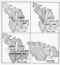
| Date: | 01 11 1805 |
|---|---|
| Description: | Four map illustrations showing the political subdivisions of the Northwest Territory from 1805 through 1834. |
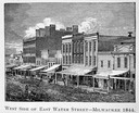
| Date: | 1844 |
|---|---|
| Description: | Illustration of the west side of East Water Street. |
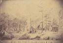
| Date: | 1862 |
|---|---|
| Description: | Sketch of the camp of the 15th Regiment of the Wisconsin Volunteer Infantry on Island No. 10 during the Civil War. Colonel Hans Christian Heg commanded the... |

| Date: | 1872 |
|---|---|
| Description: | The sidewheel packet, Red Wing, in the Mississippi River near Queen's Bluff below Trempealeau, Wisconsin. |

| Date: | 03 1892 |
|---|---|
| Description: | Three men are dragging their canoe upriver through a strong current. In the background other men are standing on the far river bank near canoes pulled up o... |

| Date: | 1855 |
|---|---|
| Description: | Detail from a lithograph vignette on a Map of the City of Madison of the third Wisconsin State Capitol, the first Capitol in Madison. |
| Date: | 1879 |
|---|---|
| Description: | Lithograph of voyageurs making a portage from an article on "The Honorable Hudson Bay Company" from Harpers Monthly in 1879. |
| Date: | 1874 |
|---|---|
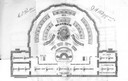
| Description: | Seating chart for the Wisconsin Senate as it appeared in the 1874 Legislative Manual, commonly called the Wisconsin Blue Book. |
| Date: | 1874 |
|---|---|
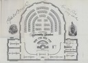
| Description: | Seating chart for members of the Wisconsin Assembly as published in the 1874 Legislative Manual, the Wisconsin Blue Book. |

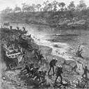
| Date: | 02 21 1874 |
|---|---|
| Description: | African American boatmen run a rapids in a small river boat. |
| Date: | 1844 |
|---|---|
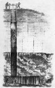
| Description: | Cross section drawing of a Wisconsin lead mine. |
| Date: | 1850 |
|---|---|
| Description: | Chippewa Indian Sugar Camp. Plate 61, preceding p. 199, vol. I, The Indian tribes of the United States: their history antiquities, customs, religion, ar... |
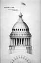
| Date: | 1884 |
|---|---|
| Description: | Drawing by architect Stephen Vaughn Shipman of the dome for the third Wisconsin State Capitol. Wisconsin selected Shipman's design for the dome because of ... |
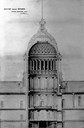
| Date: | 1857 |
|---|---|
| Description: | Section drawing of the rotunda of the third Wisconsin State Capitol (second in Madison) by Stephen V. Shipman. August Kutzbock and Samuel H. Donnel were th... |
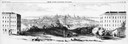
| Date: | 1858 |
|---|---|
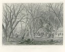
| Description: | Panoramic sketch of State Street between North and South Halls on the University of Wisconsin-Madison campus. Published in Frank Leslie's Illustrate Newsp... |
If you didn't find the material you searched for, our Library Reference Staff can help.
Call our reference desk at 608-264-6535 or email us at: