 Filter: Categories of Wisconsin Historical Images
Filter: Year of 1700-1799
Filter: Categories of Wisconsin Historical Images
Filter: Year of 1700-1799

| Date: | 1798 |
|---|---|
| Description: | Engraved and hand-colored map of Egypt. Map title appears on bottom left as a carving in stone next ... |

| Date: | 1712 |
|---|---|
| Description: | Engraved double-hemispherical world map by Moll, included in his atlas The world described, or, A new and correct sett of maps: shewing the kingdoms and st... |

| Date: | 1740 |
|---|---|
| Description: | From Weigel's Atlas portatilis, oder, Compendieuse Vorstellung der gantzen Welt. Map of Europe. |

| Date: | 1720 |
|---|---|
| Description: | Double hemispherical world map showing routes of Tasman, Magellan, Mendana, etc. Relief shown pictorially. Title in oak wreath cartouche. Map between four ... |

| Date: | 02 01 1793 |
|---|---|
| Description: | Text in the upper right corner reads, "A Map of The Western Part of the Territories belonging to the United States of America. Drawn from the best authorit... |
| Date: | 02 24 1779 |
|---|---|
| Description: | A letter from Governor Henry Hamilton to Colonel Clark proposing a truce. |

| Date: | 09 19 1787 |
|---|---|
| Description: | The first printing of the United States Constitution found in the "Pennsylvania Packet," and "Daily Advertiser." |

| Date: | 09 19 1787 |
|---|---|
| Description: | The first printing of the United States Constitution found in the "Pennsylvania Packet," and "Daily Advertiser." |
| Date: | 1719 |
|---|---|
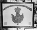
| Description: | Photograph of a framed Scottish Historical Armorial Flag. |
| Date: | 1777 |
|---|---|
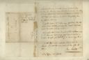
| Description: | The back side of Captin Joseph Martin's pay roll from 1 May through 30 June, 1777. There are columns of numbers beneath the writing. |
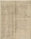
| Date: | 1777 |
|---|---|
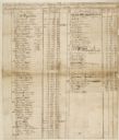
| Description: | A pay roll handwritten by Captain Joseph Martin listing men stationed on the Frontiers of Washington County under the command of Colonel Evan Shelby. |
| Date: | 1777 |
|---|---|
| Description: | A pay roll, handwritten by Captain Joseph Martin, listing men under the command of Major Bledsoe at Rye Cove on Clinck. |

| Date: | 1780 |
|---|---|
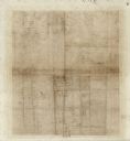
| Description: | Hand-drawn plan for the layout of the town of Clarksville, bordering Mayfield Creek and Liberty Creek. Fort Jefferson is shown between the townsite and the... |

| Date: | 1744 |
|---|---|
| Description: | A map of a plan of 16,500 acres of land. |
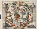
| Date: | 1745 |
|---|---|
| Description: | Zodiac as seen from the Southern Hemisphere. |
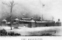
| Date: | 1790 |
|---|---|
| Description: | Fort Washington, built in 1789, where Cincinnati now stands. |

| Date: | 1745 |
|---|---|
| Description: | Zodiac as seen from the Northern Hemisphere. |
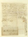
| Date: | 1786 |
|---|---|
| Description: | Letter written by Gilbert Imlay to Daniel Boone. |

| Date: | 1780 |
|---|---|
| Description: | Plan for layout of 150,00 acres which make up Clark's Illinois Grant. |
If you didn't find the material you searched for, our Library Reference Staff can help.
Call our reference desk at 608-264-6535 or email us at:
