 Filter: Categories of Wisconsin Historical Images
Filter: Subject of political science
Filter: Creator Name of Snyder Van Vechten & Co.
Filter: Categories of Wisconsin Historical Images
Filter: Subject of political science
Filter: Creator Name of Snyder Van Vechten & Co.

| Date: | 1878 |
|---|---|
| Description: | This map shows 13 districts throughout the state. Congressional districts are outlined in red and judicial districts are outlined in blue as show borders a... |

| Date: | 1878 |
|---|---|
| Description: | This map shows ward boundaries in red, as well as counties, communities, rivers, lakes, Lake Michigan, and Lake Superior. The bottom left corner includes a... |
| Date: | 1878 |
|---|---|
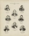
| Description: | This print shows eight former Governors of Wisconsin. In date order: "Louis P. Harvey, 1862 til April 20"; "Edward Salomon, April 20 1862-1864"; "James T. ... |
| Date: | 1878 |
|---|---|
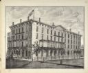
| Description: | View of Vilas House. The name on the building is Levi B. Vilas. |
If you didn't find the material you searched for, our Library Reference Staff can help.
Call our reference desk at 608-264-6535 or email us at: