 Filter: Categories of Wisconsin Historical Images
Filter: Subject of landforms
Filter: Subject of trails
Filter: Categories of Wisconsin Historical Images
Filter: Subject of landforms
Filter: Subject of trails
| Date: | |
|---|---|
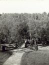
| Description: | Two people on a rustic bridge over Bad River at Copper Falls State Park. |

| Date: | 1945 |
|---|---|
| Description: | View of the lower campus of the University of Wisconsin-Madison includes Bascom Hill, Wisconsin Historical Society, Memorial Union and the Armory (Red Gym ... |

| Date: | 1923 |
|---|---|
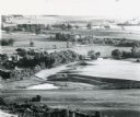
| Description: | Aerial view of the Wisconsin Historical Society, Science Hall, and Bascom Hall on Bascom Hill on the University of Wisconsin-Madison campus. Lake Mendota i... |
| Date: | 06 20 1849 |
|---|---|
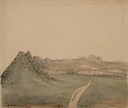
| Description: | The Black Hills sketched by Wilkins on his 151-day journey from Missouri to California on the Overland Trail (also known as the Oregon Trail). |
| Date: | 06 30 1849 |
|---|---|
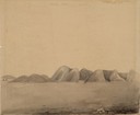
| Description: | The Red Hills sketched by Wilkins on his 151-day journey from Missouri to California on the Overland Trail (also known as the Oregon Trail). |
| Date: | 06 30 1849 |
|---|---|
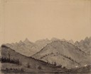
| Description: | The Black Hills sketched by Wilkins on his 151-day journey from Missouri to California on the Overland Trail (also known as the Oregon Trail). |
| Date: | |
|---|---|
| Description: | Aerial view of a portion of Ice Age Trail taken from a hot air balloon. |
| Date: | 1894 |
|---|---|
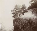
| Description: | Elevated view of three women and a young girl standing at the edge of a small cliff on the shores of Lake Mendota. Various shrubs and small trees grow on t... |
| Date: | |
|---|---|
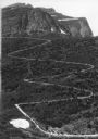
| Description: | Elevated view of a donkey train going up a zig-zag trail along the mountainside in Glacier National Park. |

| Date: | 1938 |
|---|---|
| Description: | View of a house on Nebraska Row on Madeline Island. In the foreground is a flag pole, bench, path, lawn and trees. On the left are docks from the lake shor... |

| Date: | 1837 |
|---|---|
| Description: | This map shows the townships, roads, trails, natural land forms, vegetation, mill sites and lead and copper deposits in the Wisconsin Territory at the time... |
| Date: | |
|---|---|
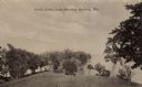
| Description: | Sepia-toned photographic postcard view looking out towards the Picnic Point Peninsula jutting out into Lake Mendota. A walking path is on the left Caption ... |
If you didn't find the material you searched for, our Library Reference Staff can help.
Call our reference desk at 608-264-6535 or email us at: