 Filter: Categories of Wisconsin Historical Images
Filter: Subject of indians of north america
Filter: Subject of tourism
Filter: Categories of Wisconsin Historical Images
Filter: Subject of indians of north america
Filter: Subject of tourism
| Date: | |
|---|---|
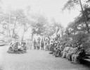
| Description: | Group of Ho-Chunk at Stand Rock Amphitheater. Several men sit in a ring as other Ho-Chunk look on. Tepee in the background. This is where the Stand Rock In... |

| Date: | |
|---|---|
| Description: | Map reads: "Historic and Scenic Wisconsin — Land of Gathering Waters." In an inset there is a hand-painted depiction of the Wisconsin State Seal. For some ... |
| Date: | |
|---|---|
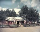
| Description: | Exterior view of Parson's Indian Village, a tourist attraction on Highway 12 styled after a Zuni pueblo. Caption reads: "Zuni Pueblo-Parson's Indian Villag... |

| Date: | |
|---|---|
| Description: | Copy photograph of six Native American men standing outdoors wearing Sioux bonnets, and original print inscribed "Riverview Boat Line Indian Guides." Possi... |
| Date: | |
|---|---|
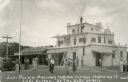
| Description: | Two men and one woman in Native American costume stand near a fence and a U.S. flag outside the entrance of Pipe Dyer's Trading Post in Fort Dells. There a... |
| Date: | |
|---|---|
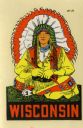
| Description: | Wisconsin promotional decal with a drawing of a Native American sitting cross-legged, wearing a headdress, buckskin, and moccasins, and holding a calumet p... |

| Date: | 1952 |
|---|---|
| Description: | The famous Dells of the Wisconsin River. A souvenir map embellished with bits of history and points of interest. |

| Date: | 1957 |
|---|---|
| Description: | Large Letter style postcard for Green Bay depicting various scenes in the letters that spell the name of the city. Caption reads: "Greetings from Green Bay... |

| Date: | 1941 |
|---|---|
| Description: | This pictorial map of Wisconsin with historical text highlights the history of the state and identifies places of interest, Indian villages, missions, trad... |
| Date: | 04 23 1936 |
|---|---|
| Description: | Drawing submitted to the State of Wisconsin for trademark registration. The red, black, and cream label features an original Indian head design, with tipis... |

| Date: | 1950 |
|---|---|
| Description: | This road map shows federal, state and county roads in Wisconsin, northern Illinois, northeastern Iowa, eastern Minnesota, and the western portion of Michi... |

| Date: | |
|---|---|
| Description: | A map of Iron County, Wisconsin, shows color-coded townships, sections, lakes and streams, villages, railroads, roads, tourist camps, and La Pointe and Lac... |
| Date: | 1929 |
|---|---|
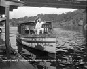
| Description: | View from pier of a Native American man wearing a headdress kneeling on a tourist boat called "Black Hawk" docked under a bridge in the Wisconsin River. He... |

| Date: | 1995 |
|---|---|
| Description: | This map of La Crosse is a bird’s-eye-view map with relief shown pictorially. The cover lists many points of interests and activities in La Crosse. The cov... |
| Date: | 1929 |
|---|---|
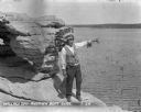
| Description: | Native American tour guide standing on a rock formation. He is wearing a headdress and decorated vest and white shirt, and is holding a megaphone and point... |
| Date: | 1929 |
|---|---|
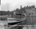
| Description: | Native American guide in native dress standing on the bow of a tour boat floating in the river. A pilot wearing a hat is sitting behind him. On the front o... |

| Date: | |
|---|---|
| Description: | Portrait of two Native American men wearing feathers and beadwork who are standing in front of a teepee, which has a thunderbird symbol inside, seen throug... |

| Date: | 1927 |
|---|---|
| Description: | Two Native American children, a girl and a boy, standing in front of a small teepee with a blanket draped over part of it. |

| Date: | 1939 |
|---|---|
| Description: | This illustrated map shows counties, highways, rivers, roads, present and proposed state parks and forests, proposed state parkways, proposed state monumen... |
| Date: | 1956 |
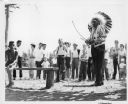
|---|---|
| Description: | Sam Blowsnake prepares to shoot an arrow with his bow as a crowd of people watches behind him. |
If you didn't find the material you searched for, our Library Reference Staff can help.
Call our reference desk at 608-264-6535 or email us at: