 Filter: Categories of Wisconsin Historical Images
Filter: Subject of indians of north america
Filter: Subject of rivers
Filter: Categories of Wisconsin Historical Images
Filter: Subject of indians of north america
Filter: Subject of rivers

| Date: | 1936 |
|---|---|
| Description: | This map is red and black ink on tracing cloth and is oriented with north to the upper left. This hand-drawn map shows a central portion of the military ro... |

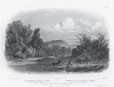
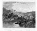
| Date: | 10 1852 |
|---|---|
| Description: | Landscape view of the river looking downstream from Fort Snelling, Minnesota Territory. An expanse of placid river water fills the center of the drawing an... |
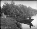
| Date: | 1899 |
|---|---|
| Description: | View along shoreline towards Indian log drivers, two in a bateau, and one man standing on the bank of the Chippewa River. |
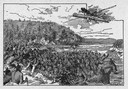
| Date: | 1845 |
|---|---|
| Description: | Illustration of Chippewa and Sioux Indians battling each other at the Brule River. Wood engraving from Armstrong, "Early Life Among The Indians." |

| Date: | 1842 |
|---|---|
| Description: | This hand-colored lithograph of the second Fort Howard, with Indians canoeing on the Fox River, shows the hospital built 1834-1835 outside the stockade on ... |

| Date: | 1886 |
|---|---|
| Description: | This map shows U.S. land offices, completed railroads, railroad land grant limits, lakes, rivers, and Indian reservations. Communities, lakes, and rivers a... |

| Date: | 1821 |
|---|---|
| Description: | Indians of the North Red River area, probably in the vicinity of old Fort Douglas, now Winnipeg, Canada, spearing beaver. |

| Date: | 1831 |
|---|---|
| Description: | Drawing of Fort Winnebago (near present-day Portage) that illustrated "Wau-Bun," Juliette Kinzie's memoir of her experiences on the early Wisconsin fronti... |
| Date: | 1832 |
|---|---|
| Description: | Engraving of Indians on horseback along river with Indian grave on hill in background. |

| Date: | 1832 |
|---|---|
| Description: | Black and white engraving showing landscape with Fort Pierre and Indian tipis along the Missouri River. |
| Date: | 1832 |
|---|---|
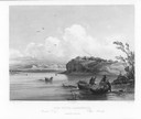
| Description: | Punka Indians encamped on the banks of the Missouri River and canoeing in river. |
| Date: | 1832 |
|---|---|
| Description: | Mih-Tutta-Hangkusch, a Mandan village with boats on the river in foreground. |

| Date: | 1832 |
|---|---|
| Description: | Junction of the Yellowstone River and the Missouri River. |
| Date: | 1832 |
|---|---|
| Description: | Camp of the Gros Ventres along the upper Missouri River, with white travelers passing by in a boat. |
| Date: | 1832 |
|---|---|
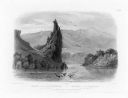
| Description: | The Citadel Rock on the Upper Missouri River. |
| Date: | 1832 |
|---|---|
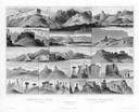
| Description: | Remarkable Hills on the Upper Missouri River (views 10-29). Various scenes of land formations. |
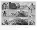
| Date: | 1832 |
|---|---|
| Description: | Remarkable hills on the Upper Missouri River (views 1-9). Various landscapes and rock formations. |
| Date: | 1832 |
|---|---|
| Description: | Herds of bison and elk on the Upper Missouri River. |

| Date: | 1832 |
|---|---|
| Description: | Fort Union, on the Missouri River in Montana. |

| Date: | 1832 |
|---|---|
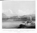
| Description: | Fort Clark, on the Missouri River, February 1834. |
If you didn't find the material you searched for, our Library Reference Staff can help.
Call our reference desk at 608-264-6535 or email us at: