Filter: Categories of Wisconsin Historical Images
Filter: Subject of indians of north america
Filter: Subject of forests and forestry
Filter: Categories of Wisconsin Historical Images
Filter: Subject of indians of north america
Filter: Subject of forests and forestry

| Date: | 10 1852 |
|---|---|
| Description: | Landscape view of the river looking downstream from Fort Snelling, Minnesota Territory. An expanse of placid river water fills the center of the drawing an... |
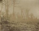
| Date: | 1898 |
|---|---|
| Description: | A forest from the Ojibwa-Pillager Battle at Sugar Point on Bear Island. |
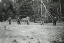
| Date: | 1943 |
|---|---|
| Description: | Menominee women working to protect their white pines from blister rust. |
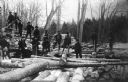
| Date: | 1909 |
|---|---|
| Description: | A group of Native American Indian loggers pose on piles of logs at the Courtes Oreilles Reservation. |

| Date: | 1939 |
|---|---|
| Description: | A color, pictorial map. Scale: 10 miles to the inch. Shows state parks and forests, proposed state parkways, proposed state monuments and memorials, nation... |

| Date: | 1936 |
|---|---|
| Description: | Loading a large white pine log cut on the Menominee Indian Reservation onto a truck. The log was hauled to the Wisconsin State Fair for a display about the... |
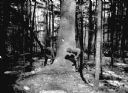
| Date: | 03 1938 |
|---|---|
| Description: | A large white pine being felled on the Menominee Indian Reservation. This photograph was taken to illustrate the tribe's selective logging practices. |
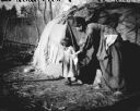
| Date: | |
|---|---|
| Description: | A Ho-Chunk woman and small child in front of a Ho-Chunk lodge. The woman and child are looking to the side. In the background are trees and shrubs. |
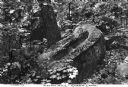
| Date: | |
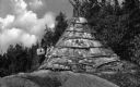
|---|---|
| Description: | View of a large carved rock on a forest floor surrounded by maple tree saplings. The rock has carved indentations for use as a mortar stone and was probabl... |

| Date: | |
|---|---|
| Description: | Campers watch Native American ceremonies while seated around the council ring at Camp St. John. The group of boys and young men gather around a fire pit, a... |
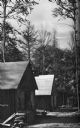
| Date: | 1936 |
|---|---|
| Description: | Exterior view of a logging camp on the Menominee Indian Reservation. The three buildings are surrounded by forest. |

| Date: | 06 1934 |
|---|---|
| Description: | This Wisconsin Conservation Department map shows national, state, and county forests both approved and pending, as well as Indian reservations in Wisconsin... |

| Date: | 1935 |
|---|---|
| Description: | "Drott's conservation guide" map shows the locations of Indian reservations, parks, fish hatcheries, forests, lookout towers, Wisconsin Conservations Commi... |

| Date: | 05 01 1938 |
|---|---|
| Description: | This map shows the locations of Wisconsin Conservation Department forest protection districts and cooperative areas, state forests, national forests, India... |

| Date: | 1939 |
|---|---|
| Description: | This nine-part map from the U.S. Bureau of Public Roads identifies federal and state highways in Wisconsin by pavement type. County, forest, park, and publ... |

| Date: | 1944 |
|---|---|
| Description: | This nine-part map from the U.S. Bureau of Public Roads identifies federal and state highways in Wisconsin by pavement type. County, forest, park, and publ... |

| Date: | |
|---|---|
| Description: | Map of northern Iron County, Wisconsin, shows town sections and railroads in the towns of Saxon, Kimball, and Gurney. It also includes the area of the La P... |
| Date: | 1929 |
|---|---|
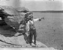
| Description: | Native American tour guide standing on a rock formation. He is wearing a headdress and decorated vest and white shirt, and is holding a megaphone and point... |
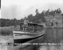
| Date: | 1929 |
|---|---|
| Description: | Native American guide in native dress standing on the bow of a tour boat floating in the river. A pilot wearing a hat is sitting behind him. On the front o... |
If you didn't find the material you searched for, our Library Reference Staff can help.
Call our reference desk at 608-264-6535 or email us at: