 Filter: Categories of Wisconsin Historical Images
Filter: Subject of indians of north america
Filter: Subject of forest conservation
Filter: Categories of Wisconsin Historical Images
Filter: Subject of indians of north america
Filter: Subject of forest conservation
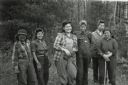
| Date: | 1943 |
|---|---|
| Description: | Ribes eradication crew of Indian women on the Menominee Reservation pose together in a line. |
| Date: | 1943 |
|---|---|
| Description: | Menominee women working to protect their white pines from blister rust. |
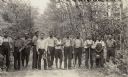
| Date: | 1933 |
|---|---|
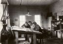
| Description: | One of the Native American crews hired to assist with the White Pine Blister Rust eradication effort on the Menominee Reservation. Joe Larock was identifie... |
| Date: | 1933 |
|---|---|
| Description: | Native Americans hired to assist with the White Pine Blister Rust eradication effort on the Menominee Reservation are being trucked to their work site. |
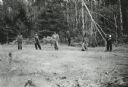
| Date: | 1933 |
|---|---|
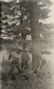
| Description: | Three men working near a tree. During 1933 Menominee Indians protected over 4000 acres of white pines from the blister rust threat. |
| Date: | 08 1935 |
|---|---|
| Description: | William Cowan, the white pine blister rust control foreman on the Menominee Reservation, with his two assistants, Joseph Dodge and Leo Waukechom (right). |

| Date: | 1936 |
|---|---|
| Description: | Loading a large white pine log cut on the Menominee Indian Reservation onto a truck. The log was hauled to the Wisconsin State Fair for a display about the... |
| Date: | 03 1938 |
|---|---|
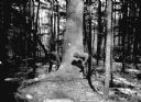
| Description: | A large white pine being felled on the Menominee Indian Reservation. This photograph was taken to illustrate the tribe's selective logging practices. |

| Date: | 1935 |
|---|---|
| Description: | "Drott's conservation guide" map shows the locations of Indian reservations, parks, fish hatcheries, forests, lookout towers, Wisconsin Conservations Commi... |

| Date: | 1937 |
|---|---|
| Description: | This map shows the Wisconsin Conservation Department forest protection divisions and the locations of state forests, national forests, Indian reservations,... |

| Date: | 1937 |
|---|---|
| Description: | This Wisconsin Conservation Department map shows the locations of state forests, national forests, county forests, state nurseries, Indian reservations, st... |

| Date: | 05 01 1938 |
|---|---|
| Description: | This map shows the locations of Wisconsin Conservation Department forest protection districts and cooperative areas, state forests, national forests, India... |

| Date: | 1935 |
|---|---|
| Description: | Two hand-colored maps of the area comprising the town of Millston (Plats of Townships 20 and 21 north, range 2 west), Jackson County, Wisconsin, showing 40... |
If you didn't find the material you searched for, our Library Reference Staff can help.
Call our reference desk at 608-264-6535 or email us at: