Filter: Categories of Wisconsin Historical Images
Filter: Subject of indians of north america
Filter: Subject of camping
Filter: Categories of Wisconsin Historical Images
Filter: Subject of indians of north america
Filter: Subject of camping
| Date: | 1889 |
|---|---|
| Description: | Beach fishing camp showing several people around a fire drying fish with a tent in the background. Captioned: Ottawa Fishing Camp -- On the Island at Fran... |
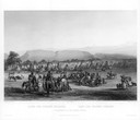
| Date: | 1832 |
|---|---|
| Description: | Punka Indians encamped on the banks of the Missouri River and canoeing in river. |
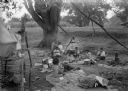
| Date: | 1925 |
|---|---|
| Description: | A Native American (possibly Ho-Chunk) family rests at their campsite under a large tree. There is a bucket suspended over a small campfire. |

| Date: | 1930 |
|---|---|
| Description: | Pictorial map of Glacier National Park, Montana and Waterton Lakes National Park, Alberta. Illustrated by Joe Scheurle, it depicts white people, American ... |
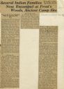
| Date: | 07 05 1928 |
|---|---|
| Description: | Article entitled "Several Indian Families Now Encamped at Frost's Woods, Ancient Camp Site" about Winnebago (Ho-Chunk) Indians camping on the shores of Lak... |
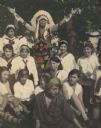
| Date: | 1930 |
|---|---|
| Description: | Hand-colored group portrait of Camp Fire girls and a man dressed in Ojibwa-style floral embroidered/beaded clothing and a Plains Indian feathered headdress... |

| Date: | 1975 |
|---|---|
| Description: | This map shows boundaries, roads, national forest land, bogs and wetlands, lakes, campgrounds, and boat landings. |

| Date: | 2000 |
|---|---|
| Description: | This map shows national parks, county and state forests, Indian reservations, municipal land, private land, docks, boat access, camping, and points of inte... |

| Date: | 1972 |
|---|---|
| Description: | This colored map displays Wisconsin and bordering areas of Iowa, Minnesota, and Michigan. There is color-coding on the map to indicate National Forests, an... |

| Date: | 1971 |
|---|---|
| Description: | This colored map displays Wisconsin and bordering areas of Iowa, Minnesota, and Michigan. There is color-coding on the map to indicate National Forests, an... |

| Date: | 1973 |
|---|---|
| Description: | This colored map displays Wisconsin and bordering areas of Iowa, Minnesota, and Michigan. There is color-coding on the map to indicate National Forests, a... |

| Date: | 1962 |
|---|---|
| Description: | This colored map represents "Tour #2" of a series of driving tours of the state published by the Sperry & Hutchinson Company, in order to "help you enjoy W... |

| Date: | 1962 |
|---|---|
| Description: | This colored map represents "Tour #1" of a series of driving tours of the state published by the Sperry & Hutchinson Company, in order to "help you enjoy W... |
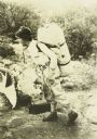
| Date: | 1910 |
|---|---|
| Description: | Carl carrying a large pack on his back and holding a bag. He is wearing a beaded belt that was almost certainly made by an Indian. |
If you didn't find the material you searched for, our Library Reference Staff can help.
Call our reference desk at 608-264-6535 or email us at: