 Filter: Categories of Wisconsin Historical Images
Filter: Subject of indians of north america
Filter: Subject of bridges
Filter: Categories of Wisconsin Historical Images
Filter: Subject of indians of north america
Filter: Subject of bridges
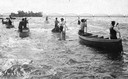
| Date: | 07 16 1898 |
|---|---|
| Description: | A group of Ojibwa men fishing from boats. |

| Date: | 1873 |
|---|---|
| Description: | Bird's-eye map of La Crosse from the Mississippi River. |
| Date: | |
|---|---|
| Description: | Billboards with advertising for the "Georgia Up-To-Date Minstrels" at the Opera House on Saturday, April 7. Bridge visible to the left. The J.J. McGillivra... |
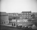
| Date: | 1911 |
|---|---|
| Description: | Four Ho-Chunk people crossing a bridge spanning the Black River. This photograph was taken before the flood of October 1911, when the bridge was completely... |
| Date: | 1913 |
|---|---|
| Description: | Portrait of Chippewa (Ojibwa) man at Bad River Indian Reservation. |

| Date: | |
|---|---|
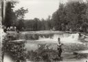
| Description: | "Peavy Falls Group" of men and boys posed on bank of river. There is a man in a canoe in the river, and a footbridge in the background. |
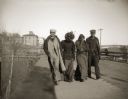
| Date: | 1929 |
|---|---|
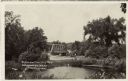
| Description: | Group of people at Bear Trap Falls in the Wolf River near Keshena. People are standing on the shoreline on the left near a sign for the falls. A man is sta... |
| Date: | |
|---|---|
| Description: | View across road of an older Ho-Chunk woman, wearing a shawl over her shoulders and several necklaces, walking across a bridge on a board sidewalk. Two oth... |

| Date: | |
|---|---|
| Description: | A Ho-Chunk woman is walking across the Black River Bridge wearing a long shawl over her shoulders and carrying a bundle. Identified as Mrs. George Funmaker... |

| Date: | 1950 |
|---|---|
| Description: | This road map shows federal, state and county roads in Wisconsin, northern Illinois, northeastern Iowa, eastern Minnesota, and the western portion of Michi... |

| Date: | 1897 |
|---|---|
| Description: | This 1897 map of Sawyer County, Wisconsin, shows the township and range system, sections, roads, farm houses, camps, school houses, dams, bridges, Indian r... |

| Date: | 1902 |
|---|---|
| Description: | This 1902 map of the eastern portion of Sawyer County, Wisconsin, shows the township and range system, sections, roads, farm houses, camps, school houses, ... |
| Date: | 1929 |
|---|---|
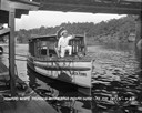
| Description: | View from pier of a Native American man wearing a headdress kneeling on a tourist boat called "Black Hawk" docked under a bridge in the Wisconsin River. He... |

| Date: | |
|---|---|
| Description: | View across unpaved road towards a Native American woman, wrapped in a plaid shawl, walking in front of a horse hitched to a wagon. On the left across the ... |

| Date: | 1907 |
|---|---|
| Description: | This blueprint map shows a proposed plan for pleasure roads and reservation system. It also shows schools, cemeteries, old river channel, proposed bridge, ... |
| Date: | |
|---|---|
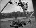
| Description: | View over water towards a road leading to a bridge. A man is standing next to an automobile on the side of the road. |
If you didn't find the material you searched for, our Library Reference Staff can help.
Call our reference desk at 608-264-6535 or email us at: