 Filter: Categories of Wisconsin Historical Images
Filter: Subject of indians of north america
Filter: Reproduction Rights of For Sale
Filter: County of Menominee
Filter: Categories of Wisconsin Historical Images
Filter: Subject of indians of north america
Filter: Reproduction Rights of For Sale
Filter: County of Menominee
| Date: | |
|---|---|
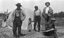
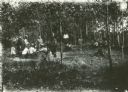
| Description: | Native Americans on the Menominee Reservation near Keshena, Wisconsin. A white man in the foreground appears to be drawing something out of camera range. T... |

| Date: | 1910 |
|---|---|
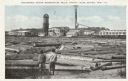
| Description: | Sawmill on a Menominee Indian reservation, with logs floating in the water in the foreground. Caption reads: "Menominee Indian Mills." |
| Date: | 1929 |
|---|---|
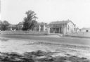
| Description: | Keshena Indian School, an Indian Government School building. |
| Date: | 1943 |
|---|---|
| Description: | Ribes eradication crew of Indian women on the Menominee Reservation pose together in a line. |
| Date: | |
|---|---|
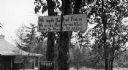
| Description: | A toll road sign on the Keshena Menominee Reservation for the Highway 55 toll road that goes through the reservation. |
| Date: | 1929 |
|---|---|
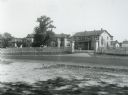
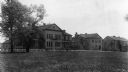
| Description: | The Government Indian School in Keshena. |
| Date: | 1929 |
|---|---|
| Description: | The U.S. Department of the Interior, Keshena Indian School. |
| Date: | 1935 |
|---|---|
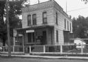
| Description: | U.S. Department of the Indian agency building on the Menominee Indian Reservation. |
| Date: | |
|---|---|
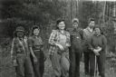
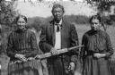
| Description: | Outdoor portrait of a Menominee Indian man and two Menominee Indian women. The man is holding a decorated ceremonial pipe in his right hand. |
| Date: | 07 28 1929 |
|---|---|
| Description: | Indian pow wow at Bear Trap Falls near Keshena. |
| Date: | 09 17 1961 |
|---|---|
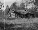
| Description: | A broken down, abandoned log shack on the Stockbridge Indian Reservation. |
| Date: | |
|---|---|
| Description: | Mill on the Menominee Indian Reservation between Antigo and Shawano. Two young boys are standing in the foreground on the shoreline looking at logs ready f... |
| Date: | |
|---|---|
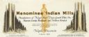
| Description: | Letterhead of Menominee Indian Mills of Neopit, Wisconsin, a mill "under supervision of the United States Department of the Interior, Office of Indian Affa... |

| Date: | 1956 |
|---|---|
| Description: | This map shows reservation boundaries, U.S. township lines, highways, roads, rivers, and lakes. The lower left corner of the map includes a legend of "Conv... |

| Date: | 1970 |
|---|---|
| Description: | This map shows land owned by Menominee Enterprise Inc., land sold to Menominee shareholders, and land sold to non-Menominees. The map also includes water a... |
| Date: | 1957 |
|---|---|
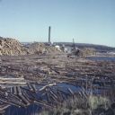
| Description: | View from shoreline of logs floating in the water of Neopit Mill Pond. The sawmill is across the water, partially obscured by tall piles of logs. |
| Date: | 1940 |
|---|---|
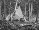
| Description: | Two large woven baskets with shoulder straps are sitting on the ground in front of an open tepee in a forest clearing. There are two tin cups on the ground... |
| Date: | 1940 |
|---|---|
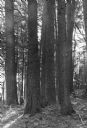
| Description: | Lear Shewano is dwarfed by a grove of huge virgin white pine trees in the Menominee Indian Reservation. He is wearing a white hat and plaid shirt. |
| Date: | |
|---|---|
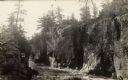
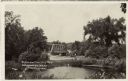
| Description: | The Dells of the Wolf River in the Menominee Indian Reservation. |
| Date: | |
|---|---|
| Description: | View over water towards a road leading to a bridge. A man is standing next to an automobile on the side of the road. |
If you didn't find the material you searched for, our Library Reference Staff can help.
Call our reference desk at 608-264-6535 or email us at: